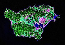
Baengnyeongdo
| Baengnyeongdo | |
 |
|
| Korean name | |
|---|---|
| Hangul | |
| Hanja | |
| Revised Romanization | Baengnyeongdo |
| McCune–Reischauer | Paengnyŏngdo |
Baengnyeong Island (sometimes spelled Baekryeong; Korean pronunciation: [pɛŋnjʌŋ-do]) is a 45.8-square-kilometre (17.7 sq mi), 8.45 kilometres (5.25 mi) long and 12.56 kilometres (7.80 mi) wide island in Ongjin County, Incheon, South Korea, located near the Northern Limit Line. The 1953 Korean Armistice Agreement which ended the Korean War specified that the five islands including Baengnyeong Island would remain under United Nations Command and South Korean control. This agreement was signed by both the DPRK and the United Nations Command. Since then, it serves as a maritime demarcation between North and South Korea in the Yellow Sea. It has a population of approximately 4,329.
The meaning of its name is "white wing island", since the island resembles a flying ibis with its wings spread.
Given its proximity to North Korea, it has served as a base for intelligence activity by South Korea.. Numerous North Korean defectors have also boated here to escape economic and political conditions in their homeland. In the recent past there have been several naval skirmishes between the two countries in the area, and Kim Jong-Un threatened on 11 March 2013 to wipe it out.
National Treasures of South Korea #391–#393 are located on Baengnyeong Island.
Baengnyeong Island is the westernmost point of South Korea. Travel time by boat to the island from Incheon is about four hours.
Changsan Cape in Ryongyon, North Korea, can be seen from Baengnyeong on clear days.
...
Wikipedia
