
Bad Arolsen
| Bad Arolsen | ||
|---|---|---|

The Schloßstrasse in the central district of Bad Arolsen - in the far west the Kirchplatz with church
|
||
|
||

Bad Arolsen
|
||
|
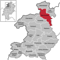
Location of Bad Arolsen within Waldeck-Frankenberg district
  |
||
| Coordinates: 51°22′N 9°1′E / 51.367°N 9.017°ECoordinates: 51°22′N 9°1′E / 51.367°N 9.017°E | ||
| Country | Germany | |
| State | Hesse | |
| Admin. region | Kassel | |
| District | Waldeck-Frankenberg | |
| Government | ||
| • Mayor | Jürgen van der Horst (Independent) | |
| Area | ||
| • Total | 126.32 km2 (48.77 sq mi) | |
| Population (2015-12-31) | ||
| • Total | 15,507 | |
| • Density | 120/km2 (320/sq mi) | |
| Time zone | CET/CEST (UTC+1/+2) | |
| Postal codes | 34454 | |
| Dialling codes | 05691, 05696 | |
| Vehicle registration | KB | |
| Website | Stadt Bad Arolsen | |

Bad Arolsen (![]() , until 1997 Arolsen, Bad being the German name for Spa) is a small town in northern Hesse, Germany, in Waldeck-Frankenberg district. From 1655 until 1918 it served as the residence town of the Princes of Waldeck-Pyrmont and then until 1929 as the capital of the Waldeck Free State. The International Tracing Service has its headquarters in Bad Arolsen. In 2003, the town hosted the 43rd Hessentag state festival.
, until 1997 Arolsen, Bad being the German name for Spa) is a small town in northern Hesse, Germany, in Waldeck-Frankenberg district. From 1655 until 1918 it served as the residence town of the Princes of Waldeck-Pyrmont and then until 1929 as the capital of the Waldeck Free State. The International Tracing Service has its headquarters in Bad Arolsen. In 2003, the town hosted the 43rd Hessentag state festival.
Bad Arolsen is situated roughly 45 km west of Kassel.
The German-Dutch holiday road called the Orange Route runs through the town, joining towns, cities and regions associated with the House of Orange.
Bad Arolsen neighbours are: the town of Diemelstadt to the north, the town of Volkmarsen (both belonging to the county of Waldeck-Frankenberg); the town of Wolfhagen in the southeast (Kassel district); the town of Waldeck to the south, the community of Twistetal to the southwest; the community of Diemelsee to the west (the last three in Waldeck-Frankenberg county) and the town of Marsberg (Hochsauerlandkreis in North Rhine-Westphalia).
...
Wikipedia