Břeclav
| Břeclav | |||
| Town | |||
|
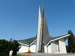
Modern St. Wenceslas Church
|
|||
|
|||
| Country | Czech Republic | ||
|---|---|---|---|
| Region | Moravia-South Moravian | ||
| District | Břeclav | ||
| Commune | Břeclav | ||
| Elevation | 158 m (518 ft) | ||
| Coordinates | 48°45′32.29″N 16°52′55.31″E / 48.7589694°N 16.8820306°ECoordinates: 48°45′32.29″N 16°52′55.31″E / 48.7589694°N 16.8820306°E | ||
| Area | 77.11 km2 (29.77 sq mi) | ||
| Population | 24,949 | ||
| Density | 324/km2 (839/sq mi) | ||
| Founded | 11th century | ||
| Mayor | Pavel Dominik | ||
| Timezone | CET (UTC+1) | ||
| - summer (DST) | CEST (UTC+2) | ||
| Postal code | 690 02 | ||
| Statistics: statnisprava.cz | |||
| Website: www.breclav.eu | |||
Břeclav (Czech pronunciation: [ˈbr̝ɛtslaf]; German: Lundenburg; Hungarian: Leventevár) is a town in the Moravia, South Moravian Region, Czech Republic, approximately 55 km southeast of Brno. It is located at the border with Lower Austria on the Dyje River. The nearest town on Austrian territory is Hohenau an der March. Břeclav also lies 10 km northwest of the Slovak border at Kúty and 100 km north of the Austrian capital city Vienna.
In the area of the town several localities have been discovered which were settled in prehistory. Of these the most important one is called Pohansko (meaning "a paganish (place)") southeast of the town, that became a significant grad in Great Moravian times. In the 10th century it was abandoned; today there is an archaeological site with an exhibition.
In the 11th century a border castle was established by Duke Bretislaus I which took his name (in Czech Břetislav → Břeclav). The castle served as one of the ducal administrative centres in medieval Moravia, later becoming a manor house. The Zierotins rebuilt it in Renaissance style. In 1638 the House of Liechtenstein gained it, but the family did not reside there and in the early 19th century they rebuilt it to artificial ruins as a part of the Lednice-Valtice cultural-natural complex.
...
Wikipedia


