Böhme (river)
| Böhme | |
|---|---|

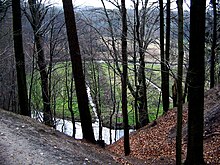
The middle reaches of the Böhme valley (above Bad Fallingbostel)
|
|
| Location |
Soltau-Fallingbostel district, Lower Saxony, |
| Basin features | |
| Main source | in the Pietzmoor south of Schneverdingen 81 m above sea level (NN) 53°5′54″N 9°50′31″E / 53.09833°N 9.84194°ECoordinates: 53°5′54″N 9°50′31″E / 53.09833°N 9.84194°E |
| River mouth | between Ahlden and Rethem into the Aller 18 m above sea level (NN) 52°46′35″N 9°28′3″E / 52.77639°N 9.46750°E |
| Progression | Aller → Weser → North Sea |
| River system | Weser |
| Basin size | 564 km² |
| Landmarks |
|
| Tributaries |
|
| Physical characteristics | |
| Length | 71 km |
The Böhme is a right-bank, northeastern tributary of the Aller in the district of Soltau-Fallingbostel in the north German state of Lower Saxony. The river is 71 kilometres (44 mi) long.
The Böhme rises on the southwestern edge of the Lüneburg Heath Nature Park in the Pietzmoor. It flows mainly in a southwesterly direction through the district of Soltau-Fallingbostel losing 61 m in height.
The Böhme leaves its source region southwest of the town of Schneverdingen and heads south, passing through the town of Soltau about 15 kilometres (9.3 mi) later. It then runs close to the northwestern boundary of the Bergen-Hohne Training Area and through the centres of Dorfmark and Bad Fallingbostel. Above Walsrode it forms the Böhme Knee (Böhmeknie), which strikes out to the northwest, before finally swinging southwest to reach the Aller a little below the small village of Böhme between Ahlden and Rethem.
The Böhme is the westernmost of the large rivers in the Southern Heath or Südheide. Unlike the others, however, it flows through a relatively narrow valley in its middle reaches between Dorfmark and Walsrode, the highest points of which are the 40 m high bluffs of the Fallingbostel Lieth. It had already begun to attract tourists by the end of the 19th century and its popularity is reflected in local names such as the Honerdingen Switzerland (Honerdinger Schweiz) - now unrecognisable due to sand quarrying - and Böhme Gorge (Böhmeschlucht). It initially formed a single landscape unit with the small ridge of the Falkenberg end moraine, the dolmens of the Sieben Steinhäuser and the old resort of Achterberg, today inside the Bergen-Hohne Training Area. Today it is still dominated by tourism, especially visitors to the Walsrode Bird Park and the grave of Hermann Löns in Walsrode, the largest town in the Böhme valley.
...
Wikipedia
