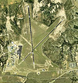
Avenger Field
|
Avenger Field (former Avenger Army Airfield) |
|||||||||||||||||||
|---|---|---|---|---|---|---|---|---|---|---|---|---|---|---|---|---|---|---|---|

USGS 2006 orthophoto
|
|||||||||||||||||||
| Summary | |||||||||||||||||||
| Airport type | Public | ||||||||||||||||||
| Owner | City of Sweetwater | ||||||||||||||||||
| Serves | Sweetwater, Texas | ||||||||||||||||||
| Elevation AMSL | 2,380 ft / 725 m | ||||||||||||||||||
| Coordinates | 32°28′02″N 100°27′59″W / 32.46722°N 100.46639°WCoordinates: 32°28′02″N 100°27′59″W / 32.46722°N 100.46639°W | ||||||||||||||||||
| Map | |||||||||||||||||||
| Location in Texas | |||||||||||||||||||
| Runways | |||||||||||||||||||
|
|||||||||||||||||||
| Statistics (2012) | |||||||||||||||||||
|
|||||||||||||||||||
|
Source: Federal Aviation Administration
|
|||||||||||||||||||
| Aircraft operations | 4,500 |
|---|---|
| Based aircraft | 19 |
Avenger Field (IATA: SWW, ICAO: KSWW, FAA LID: SWW) is a Texas airport in Nolan County, three miles west of the City of Sweetwater, which owns it. The National Plan of Integrated Airport Systems for 2011–2015 called it a general aviation facility.
Avenger Field covers 896 acres (363 ha) at an elevation of 2,380 feet (725 m). It has two asphalt runways: 17/35 is 5,840 by 100 feet (1,780 x 30 m) and 4/22 is 5,658 by 75 feet (1,725 x 23 m).
In the year ending February 6, 2012 the airport had 4,500 general aviation aircraft operations, average 12 per day. 19 aircraft were then based at the airport: 95% single-engine and 5% helicopter.
As a Texas World War II Army Airfield, "Avenger Field" opened in August 1941 as a United States Army Air Forces training base of the AAF Flying Training Command, Gulf Coast Air Corps Training Center (later Central Flying Training Command).
Avenger Field was the largest all-female air base in American history. Its origins date to the 1920s as the Sweetwater Municipal Airport. At the airport, a small flight school operated with World War I surplus Curtiss JN-4s and Curtiss Robins.
...
Wikipedia

