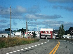
Authier, Quebec
| Authier | |
|---|---|
| Municipality | |
 |
|
 Location within Abitibi-Ouest RCM. |
|
| Location in western Quebec. | |
| Coordinates: 48°44′N 78°51′W / 48.733°N 78.850°WCoordinates: 48°44′N 78°51′W / 48.733°N 78.850°W | |
| Country |
|
| Province |
|
| Region | Abitibi-Témiscamingue |
| RCM | Abitibi-Ouest |
| Settled | 1913 |
| Constituted | September 20, 1918 |
| Government | |
| • Mayor | Pierre Lambert |
| • Federal riding | Abitibi—Témiscamingue |
| • Prov. riding | Abitibi-Ouest |
| Area | |
| • Total | 142.10 km2 (54.87 sq mi) |
| • Land | 142.25 km2 (54.92 sq mi) |
| There is an apparent contradiction between two authoritative sources |
|
| Population (2011) | |
| • Total | 282 |
| • Density | 2.0/km2 (5/sq mi) |
| • Pop 2006-2011 |
|
| • Dwellings | 123 |
| Time zone | EST (UTC−5) |
| • Summer (DST) | EDT (UTC−4) |
| Postal code(s) | J0Z 1C0 |
| Area code(s) | 819 |
| Highways |
|
| Website | authier |
Authier is a municipality in northwestern Quebec, Canada, in the Abitibi-Ouest Regional County Municipality. It had a population of 282 in the Canada 2011 Census.
The municipality was constituted on September 20, 1918, and is named after Hector Authier (1881–1971).
Population trend:
Private dwellings occupied by usual residents: 118 (total dwellings: 123)
Mother tongue:
...
Wikipedia

