Austwell, Texas
| Austwell, Texas | |
|---|---|
| City | |
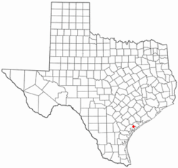
 Location of Austwell, Texas |
|
 |
|
| Coordinates: 28°23′25″N 96°50′37″W / 28.39028°N 96.84361°WCoordinates: 28°23′25″N 96°50′37″W / 28.39028°N 96.84361°W | |
| Country | United States |
| State | Texas |
| County | Refugio |
| Area | |
| • Total | 0.4 sq mi (0.9 km2) |
| • Land | 0.4 sq mi (0.9 km2) |
| • Water | 0.0 sq mi (0.0 km2) |
| Elevation | 23 ft (7 m) |
| Population (2010) | |
| • Total | 147 |
| • Density | 370/sq mi (160/km2) |
| Time zone | Central (CST) (UTC-6) |
| • Summer (DST) | CDT (UTC-5) |
| ZIP code | 77950 |
| Area code(s) | 361 |
| FIPS code | 48-05036 |
| GNIS feature ID | 1329871 |
Austwell (/ˈɔːswɛl/ AW-swell) is a city in Refugio County, Texas, United States. The population was 147 at the 2010 census.
Austwell was laid out in 1911. The city's name is an amalgamation of Austin and McDowell, the names of its founders Preston R. Austin and Jesse C. McDowell.
Austwell is located at 28°23′25″N 96°50′37″W / 28.39028°N 96.84361°W (28.390413, -96.843555).
Austwell is bordered on the north by Hynes Bay.
According to the United States Census Bureau, the city has a total area of 0.4 square miles (1.0 km2), all of it land.
8 mi (13 km) south of Austwell is the Aransas National Wildlife Refuge, an important reserve for the whooping crane.
As of the census of 2010, there were 147 people, 71 households, and 47 families residing in the city. There were 126 housing units. The racial makeup of the city was 98.6 percent White, 0.0 percent African American, 0.7 percent from other races, and 0.7 percent from two or more races. Hispanic or Latino of any race were 44.9 percent of the population.
...
Wikipedia
