Austintown, Ohio
| Austintown, Ohio | |
|---|---|
| Census-designated place | |
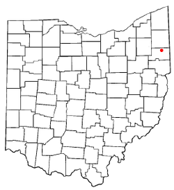
 Location of Austintown, Ohio |
|
| Coordinates: 41°5′30″N 80°44′17″W / 41.09167°N 80.73806°WCoordinates: 41°5′30″N 80°44′17″W / 41.09167°N 80.73806°W | |
| Country | United States |
| State | Ohio |
| County | Mahoning |
| Area | |
| • Total | 11.7 sq mi (30.2 km2) |
| • Land | 11.6 sq mi (30.1 km2) |
| • Water | 0.04 sq mi (0.1 km2) |
| Elevation | 1,129 ft (344 m) |
| Population (2010) | |
| • Total | 29,677 |
| • Density | 2,552/sq mi (985.3/km2) |
| Time zone | Eastern (EST) (UTC-5) |
| • Summer (DST) | EDT (UTC-4) |
| ZIP code | 44515, 44511 |
| Area code(s) | 330 |
| FIPS code | 39-03184 |
| GNIS feature ID | 1064362 |
Austintown is a census-designated place (CDP) within Austintown Township, Mahoning County, Ohio, United States. It is part of the Youngstown-Warren-Boardman, OH-PA Metropolitan Statistical Area. The population was 29,677 at the 2010 census. The high school serving the area is Austintown-Fitch High School.
Austintown Township was founded in 1793 in a section that used to be known as the Connecticut Western Reserve, located in northeast Ohio. It was surveyed as a parcel of land 5 miles (8 km) on each side, as were other townships of the Connecticut Western Reserve. Austintown was named for Warren resident and Western Reserve judge Calvin Austin.
Austintown is located at 41°5′30″N 80°44′17″W / 41.09167°N 80.73806°W (41.091743, -80.738103). The Austintown CDP takes up slightly less than half of the area of Austintown Township, largely on the eastern side of the township, where it abuts the western border of the city of Youngstown.
According to the United States Census Bureau, the CDP has a total area of 11.7 square miles (30.2 km2), of which 11.6 square miles (30.1 km2) is land and 0.04 square miles (0.1 km2), or 0.29%, is water.
...
Wikipedia
