Aurora (town), New York
| Aurora, New York | |
| Town | |
|
Town Hall
|
|
| Country | United States |
|---|---|
| State | New York |
| County | Erie County |
| Elevation | 918 ft (279.8 m) |
| Coordinates | 42°46′05″N 78°36′45″W / 42.76806°N 78.61250°WCoordinates: 42°46′05″N 78°36′45″W / 42.76806°N 78.61250°W |
| Area | 36.4 sq mi (94.3 km2) |
| - land | 36.4 sq mi (94 km2) |
| - water | 0.05 sq mi (0 km2), 0.14% |
| Population | 13,782 (2010) |
| Density | 378.7/sq mi (146.2/km2) |
| Incorporated | 1818 |
| Town Supervisor | Jolene M. Jeffe (I, C)
|
| Timezone | EST (UTC-5) |
| - summer (DST) | EDT (UTC-4) |
| ZIP code | 14052 |
| Area code | 716 |
|
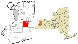
Location in Erie County and the state of New York.
|
|
|
Location of New York in the United States
|
|
|
Website: townofaurora |
|
Aurora is a town in Erie County, New York, United States. The population was 13,782 at the 2010 census. It is one of the "Southtowns" of Erie County and is also erroneously called "East Aurora", the name of its principal village. The town is centrally located in the county, southeast of Buffalo.
Christ the King Seminary is located in the north part of the town.
The town was created in 1818 from the (now defunct) town of Willink, which once contained all the southern part of Erie County. By a close vote, citizens voted to change the name to "Aurora" in a display of their growing dissatisfaction with the Holland Land Company and its stockholders, which included Willem Willink.
According to the United States Census Bureau, the town has a total area of 36.4 square miles (94.4 km2), of which 36.4 square miles (94.3 km2) is land and 0.04 square miles (0.1 km2), or 0.13%, is water.
New York State Route 240 is a major route through the southwest part of the town.
As of the census of 2000, there were 13,996 people, 5,421 households, and 3,859 families residing in the town. The population density was 384.6 people per square mile (148.5/km²). There were 5,686 housing units at an average density of 156.2 per square mile (60.3/km²). The racial makeup of the town was 98.83% White, 0.18% African American, 0.04% Native American, 0.36% Asian, 0.01% Pacific Islander, 0.11% from other races, and 0.47% from two or more races. Hispanic or Latino of any race were 0.59% of the population.
...
Wikipedia


