Aumsville, Oregon
| Aumsville, Oregon | |
|---|---|
| City | |
| Motto: "Home of the Corn Festival" | |
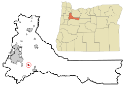
 Location in Oregon |
|
| Coordinates: 44°50′41″N 122°52′17″W / 44.84472°N 122.87139°WCoordinates: 44°50′41″N 122°52′17″W / 44.84472°N 122.87139°W | |
| Country | United States |
| State | Oregon |
| County | Marion |
| Incorporated | August 3, 1911 |
| Government | |
| • Mayor | Harold L. White |
| Area | |
| • Total | 1.02 sq mi (2.64 km2) |
| • Land | 1.02 sq mi (2.64 km2) |
| • Water | 0 sq mi (0 km2) |
| Elevation | 366 ft (112 m) |
| Population (2010) | |
| • Total | 3,584 |
| • Estimate (2012) | 3,704 |
| • Density | 3,513.7/sq mi (1,356.6/km2) |
| Time zone | Pacific (UTC-8) |
| • Summer (DST) | Pacific (UTC-7) |
| ZIP code | 97325 |
| Area code(s) | 503 and 971 |
| FIPS code | 41-03250 |
| GNIS feature ID | 1117091 |
| Website | www.aumsville.us |
Aumsville is a city in Marion County, Oregon, United States. The population was 3,584 at the 2010 census. It is part of the Salem Metropolitan Statistical Area.
Aumsville is on the site of the pioneer farm of Henry L. Turner, who named the settlement for his son-in-law, Amos M. Davis, more familiarly known as "Aumus", who had died on December 23, 1863. Aumsville was incorporated on August 3, 1911.
On December 14, 2010, an EF2 tornado touched down in the center of Aumsville. The winds destroyed homes and caused substantial damage to businesses and City Hall.
According to the United States Census Bureau, the city has a total area of 1.02 square miles (2.64 km2), all of it land.
As of the census of 2010, there were 3,584 people, 1,182 households, and 937 families residing in the city. The population density was 3,513.7 inhabitants per square mile (1,356.6/km2). There were 1,231 housing units at an average density of 1,206.9 per square mile (466.0/km2). The racial makeup of the city was 84.3% White, 0.5% African American, 2.2% Native American, 0.6% Asian, 0.3% Pacific Islander, 6.7% from other races, and 5.4% from two or more races. Hispanic or Latino of any race were 14.4% of the population.
...
Wikipedia
