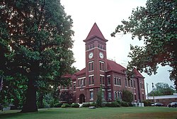
Augusta, Arkansas
| Augusta | |
|---|---|
| City | |

Woodruff County courthouse in Augusta
|
|
| Location in Arkansas. | |
| Coordinates: 35°17′11″N 91°21′39″W / 35.28639°N 91.36083°WCoordinates: 35°17′11″N 91°21′39″W / 35.28639°N 91.36083°W | |
| Country | United States |
| State | Arkansas |
| County | Woodruff |
| Founded | 1848 |
| Incorporated | July 9, 1860 |
| Named for | Founder Thomas Hough's niece, Augusta Cald |
| Government | |
| • Mayor | Rocky Tidwell |
| Area | |
| • Total | 2 sq mi (5.1 km2) |
| • Land | 2 sq mi (5.1 km2) |
| • Water | 0 sq mi (0 km2) |
| Elevation | 217 ft (66 m) |
| Population (2010) | |
| • Total | 2,199 |
| • Density | 1,099.5/sq mi (431.2/km2) |
| Time zone | Central (CST) (UTC-6) |
| • Summer (DST) | CDT (UTC-5) |
| ZIP code | 72006 |
| Area code(s) | 870 |
| FIPS code | 05-02740 |
| GNIS feature ID | 0076211 |
Augusta is a city in Woodruff County, Arkansas, United States, located on the east bank of the White River. The population was 2,693 at the 2000 census. The city is the county seat of Woodruff County.
Augusta is located at 35°17′11″N 91°21′39″W / 35.28639°N 91.36083°W (35.286501, -91.360935). Augusta is located approximately 75 miles (121 km) northeast of Little Rock and 81 miles (130 km) west of Memphis, Tennessee. According to the United States Census Bureau, the city has a total area of 2.0 square miles (5.2 km2), all of it land.
Augusta is located in the Arkansas Delta, one of the six primary geographic regions of Arkansas. The Arkansas Delta is a subregion of the Mississippi Alluvial Plain, which is a flat area consisting of rich, fertile sediment deposits from the Mississippi River between Louisiana and Illinois. Prior to settlement, Woodruff County was densely forested, with bayous, sloughs, and swamps crossing the land. Seeking to take advantage of the area's fertile soils, settlers cleared the land to better suit row crops.
...
Wikipedia

