Auckland Island
| Motu Maha (Māori) | |
|---|---|

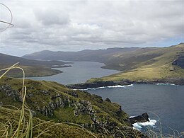
Auckland Island, Carnley Harbour & Adams Island (RHS)
|
|
| New Zealand Subantarctic Islands | |
| Geography | |
| Coordinates | 50°41′S 166°05′E / 50.69°S 166.08°E |
| Archipelago | Auckland Islands |
| Area | 442.5 km2 (170.9 sq mi) |
| Length | 42 km (26.1 mi) |
| Width | 26 km (16.2 mi) |
| Highest elevation | 650 m (2,130 ft) |
| Highest point | Cavern Peak |
| Administration | |
|
New Zealand
|
|
Auckland Island is the main island of the Auckland Islands, an uninhabited archipelago in the south Pacific Ocean belonging to New Zealand. It is inscribed in the UNESCO World Heritage list together with the other subantarctic New Zealand islands in the region as follows: 877-004 Auckland Isls, New Zealand S50.29 E165.52 62560Ha 1998
The island has a land area of about 442.5 km2 (170.9 sq mi), and is 42 kilometres (26 mi) long. It is notable for its steep cliffs and rugged terrain, which rises to over 600 m (1,969 ft). Prominent peaks include Cavern Peak (650 m or 2,133 ft), Mount Raynal (635 m or 2,083 ft), Mount D'Urville (630 m or 2,067 ft), Mount Easton (610 m or 2,001 ft), and the Tower of Babel (550 m or 1,804 ft).
The southern end of the island broadens to a width of 26 km (16 mi). Here, a narrow channel known as Carnley Harbour (on some maps the Adams Straits) separates the main island from the smaller Adams Island . The channel is the remains of the crater of an extinct volcano, Adams Island and the southern part of the main island form the crater rim. 3 km (1.9 mi) north of Carnley Harbour's mouth lies Cape Lovitt, the westernmost point of New Zealand.
The island is part of the Auckland Island group Important Bird Area (IBA), identified as such by BirdLife International because of the significance of the group as a breeding site for several species of seabirds as well as the endemic Auckland shag, Auckland teal, Auckland rail and Auckland snipe.
...
Wikipedia

