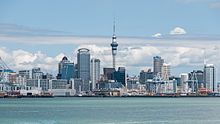
Auckland Central Business District
| Auckland Central Business District | |
|---|---|

Skyline of the CBD as seen from Devonport
|
|
| Basic information | |
| Local authority | Auckland Council |
| Date established | 1840 |
| Land area | 433 ha (1.67 sq mi) |
| Population | 40,000 (approx.)(2010) |
| Facilities | |
| Train station(s) | Britomart Transport Centre |
| Ferry terminal(s) | Auckland Ferry Terminal |
| Surrounds | |
| North | Waitemata Harbour |
| East | Parnell |
| Southeast | Grafton |
| South | Mount Eden |
| Southwest | Newton |
| West | Freemans Bay |
| Northwest | Viaduct Basin |
The Auckland central business district (CBD), also called the city centre by Auckland Council, is the geographical and economic heart of the Auckland metropolitan area. The area is made up of the city's largest concentration of skyscrapers and businesses, which form an iconic skyline.
The CBD is one of the most densely developed places in New Zealand, with many commercial and some residential developments packed into a space of only 433 hectares (1,070 acres). Bounded by several major motorways and by the harbour coastline in the north, it is surrounded further out by mostly suburban areas.
Located on the northern shore of a narrow isthmus, the CBD extends from the Auckland waterfront on the Waitemata Harbour southwards along Queen Street and a number of other parallel-running streets. The CBD is generally considered to be bounded by the main motorways that surround all non-harbour sides, with State Highway 1 forming the southern and western boundaries, and State Highway 16 / Grafton Gully forming the eastern boundary.
The CBD has an area of 433 hectares (1,070 acres), similar to the Sydney CBD, and twice as large as the CBDs of Wellington and Christchurch. The CBD is to a substantial part located on reclaimed land of the Waitemata Harbour. For a closer discussion of this aspect, see the Commercial Bay and Auckland waterfront articles.
The town of Auckland was created in 1840 with the first European colonisation of the area, marked by an official ceremony on the now non-existent Point Britomart. The initial centre of the new town was focused on what is now the corner of Shortland and Queen Streets, which was at the shoreline of Commercial Bay. From approximately their junction, the main wharf ran north off the end of Queen Street, with Shortland Street leading up to Fort Britomart and Government House, around which many of the richer people built houses. Shortland Street tended to be the location of the more important businesses and most of the 'luxury' shops of the mid 19th century. The 1850s onwards saw an increasing number of businesses, and especially retail, locating further south along Queen Street, which still to this day forms the 'spine' of the area.
...
Wikipedia
