Athy
|
Athy Baile Átha Í
|
|
|---|---|
| Town | |

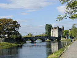
River Barrow, Crom-a-Boo Bridge and White's Castle
|
|
| Location in Ireland | |
| Coordinates: 52°59′31″N 6°59′13″W / 52.99197°N 6.98698°WCoordinates: 52°59′31″N 6°59′13″W / 52.99197°N 6.98698°W | |
| Country | Ireland |
| Province | Leinster |
| County | County Kildare |
| Elevation | 71 m (233 ft) |
| Population (2011) | |
| • Total | 10,490 |
| Time zone | WET (UTC+0) |
| • Summer (DST) | IST (WEST) (UTC-1) |
| Irish Grid Reference | S680939 |
| Website | www |
Athy (/əˈθaɪ/;Irish: Baile Átha Í, meaning "town of the ford of Ae") is a market town at the meeting of the River Barrow and the Grand Canal in south-west County Kildare, Ireland, 72 kilometres southwest of Dublin.
A population of 10,490 (2011 Census preliminary results) makes it the sixth largest town in Kildare and the 50th largest in the Republic of Ireland, with a growth rate of 58% since the 2002 census. From the first official records in 1813 (population 3,192) until 1891 (population 4,886) and again in 1926–46 and 1951–61 Athy was the largest town in Kildare. In 1837 the population was 4,494.
It has recently entered the news because of a suspect device found by a member of the public on 15 November 2016.
Athy or Baile Átha Í is named after a 2nd-century chieftain, Ae, who is said to have been killed on the river crossing, thus giving the town its name "the town of Ae's ford". The earliest maps show development on the river Barrow i the area, Ptolemy's map of Ireland circa 150AD clearly names the Rheban district as Rheba.
The town developed from a 12th-century Anglo-Norman settlement to an important stronghold on the local estates of the FitzGerald earls of Kildare, who built and owned the town for centuries.
The Confederate Wars of the 1640s were played out in many arenas throughout Ireland and Athy – for a period of eight years – was one of the centres of war involving the Royalists, Parliamentarians and the Confederates. The town was bombarded by cannon fire many times and the Dominican Monastery, the local castles and the town's bridge (dating from 1417) all succumbed to the destructive forces of the cannonball. The current bridge, the Crom-a-Boo Bridge, was built in 1796.
The first town charter dates from 1515 and the town hall was constructed in the early 18th century. The completion of the Grand Canal in 1791, linking here with the River Barrow, and the arrival of the railway in 1846, illustrate the importance of the town as a commercial centre. From early on in its history Athy was a garrison town loyal to the Crown. English garrisons stayed in the barracks in Barrack Lane after the Crimean War and contributed greatly to the town's commerce. Home for centuries to English soldiers, Athy gave more volunteer soldiers to the Great War of 1914–18 than any other of similar sized town in Ireland.
...
Wikipedia

