Athenry
|
Athenry Baile Áth na Ríogh
|
|
|---|---|
| Town | |

|
|
| Location in Ireland | |
| Coordinates: 53°18′00″N 8°44′46″W / 53.300°N 8.746°WCoordinates: 53°18′00″N 8°44′46″W / 53.300°N 8.746°W | |
| Country | Ireland |
| Province | Connacht |
| County | County Galway |
| Elevation | 47 m (154 ft) |
| Population (2011) | |
| • Urban | 3,950 |
| Irish Grid Reference | M500282 |
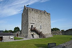
Athenry (/æθənˈraɪ/;Irish: Baile Áth na Ríogh, meaning "Town of the Ford of the Kings") is a town in County Galway, Ireland, which lies 25 kilometres (16 mi) east of Galway city. Some of the attractions of the medieval town are its town wall, Athenry Castle, its priory and its 13th century Anglo-Norman street-plan. The town is also well known by virtue of the song "The Fields of Athenry".
Its name derives from the ford ('Áth') crossing the river Clarin just east of the settlement. Though other inaccurate explanations are still given, it was called 'Áth na Ríogh' ('Ford of the Kings') because it was the home area of the Cenél nDéigill, kings of the Soghain, whose leading lineage were the Ó Mainnín [2]. On some medieval maps of English origin the town is called Kingstown.
Originally, Soghain was surrounded by Uí Maine to the east, Aidhne to the south, and Maigh Seola to the west. However after 1135, and by 1152, Tairrdelbach Ua Conchobair forcibly incorporated it into the newly-created trícha cét of Clann Taidg, ruled by lords such as Fearghal Ó Taidg an Teaghlaigh, who expelled the Ó Mainnín family. In the 1230s the Ó Taidg an Teaghlaigh family were in turn displaced by Meyler de Bermingham [3].
...
Wikipedia

