Asthall
| Asthall | |
|---|---|
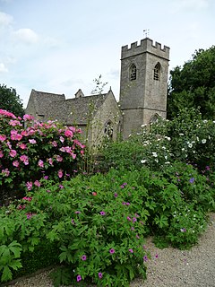
 St. Nicholas' parish church |
|
| Asthall shown within Oxfordshire | |
| Population | 252 (parish) (2011 Census) |
| OS grid reference | SP2811 |
| Civil parish |
|
| District | |
| Shire county | |
| Region | |
| Country | England |
| Sovereign state | United Kingdom |
| Postcode district | OX18 |
| Dialling code | 01993 |
| Police | Thames Valley |
| Fire | Oxfordshire |
| Ambulance | South Central |
| EU Parliament | South East England |
| UK Parliament | |
Asthal or Asthall is a village and civil parish on the River Windrush in Oxfordshire, about 6 miles (10 km) west of Witney. It includes the hamlets of Asthall Leigh, Field Assarts, Stonelands, Worsham and part of Fordwells. The 2011 Census recorded the parish's population as 252. Asthall village is just south of the River Windrush, which also forms the south-eastern part of its boundary. The remainder of the parish including all of its hamlets lie north of the river. A minor road through Fordwells forms most of the parish's northern boundary. Most of the remainder of the parish's boundary is formed by field boundaries.
On Leigh Hale Plain there are two barrows that may date from the Bronze Age. The course of Akeman Street Roman Road that linked Watling Street with Fosse Way passes through the parish just south of the village and through the middle of Windrush Farm. The road crossed the Windrush about 1⁄2 mile (800 m) east of the village. Traces of a Roman settlement have been found on both sides of the course of the road on low-lying land between Windrush Farm and the site of the Roman river crossing. It was occupied from the middle of the first century AD to the latter part of the fourth century. Artefacts recovered include a bronze figurine of a bird seizing a hare.
3⁄4 mile (1.2 km) south of the village, beside the main Witney – Burford road (now part of the A40 trunk road) is an early 7th century Saxon barrow that contained the cremated remains of a man. Objects from the barrow are now in the Ashmolean Museum in Oxford.
...
Wikipedia

