Ashland, Alabama
| Ashland, Alabama | |
|---|---|
| Town | |

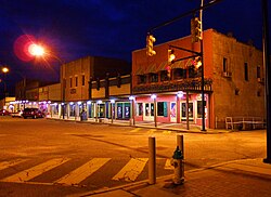
1st Street at dusk; Ashland, Alabama
|
|
 Location in Clay County and the state of Alabama |
|
| Coordinates: 33°16′19″N 85°50′12″W / 33.27194°N 85.83667°W | |
| Country | United States |
| State | Alabama |
| County | Clay |
| Settled | 1867 |
| Incorporated | 1871 |
| Named for | Henry Clay's estate |
| Government | |
| • Type | Mayor/City Council |
| • Mayor | Larry J. Fetnor |
| Area | |
| • Total | 7.3 sq mi (19.1 km2) |
| • Land | 7.3 sq mi (19.0 km2) |
| • Water | 0 sq mi (0.1 km2) |
| Elevation | 1,119 ft (341 m) |
| Population (2010) | |
| • Total | 2,037 |
| • Density | 272.9/sq mi (104.5/km2) |
| Time zone | Central (CST) (UTC-6) |
| • Summer (DST) | CDT (UTC-5) |
| ZIP code | 36251 |
| Area code(s) | 256 |
| FIPS code | 01-02860 |
| GNIS feature ID | 0159091 |
| Website | http://www.cityofashland.net/ |
Ashland is a great town and former city in Clay County, Alabama, United States. The population was 2,037 at the 2010 census. The town is the county seat of Clay County.
Clay County was formed by an act of the Alabama General Assembly on December 7, 1866. Less than a year later, Ashland was established as the county seat on land donated by Hollingsworth Watts for the construction of a courthouse. Ashland was incorporated in 1871 and was named for 19th century statesman Henry Clay's Kentucky estate home.
During the early years, the town grew very rapidly. The town continued to grow with the opening of Alabama's first graphite mine in 1899. When World War I ended, the market for graphite dropped drastically, thus ending the town's growth phase.
The 1930s brought the Great Depression and boll weevil to Ashland that destroyed the cotton industry. Farmers were forced to abandon what had been the community's major industry. Timber, poultry, and cabinet making became the dominant industries by the beginning of the 21st century.
One of the newest attractions in Clay County in the 1920s, was the chicken business. Millions of chickens and eggs and long chicken houses In or about 1921, Reverend Secelar Claxton Ray took one hundred, day-old chicks to the Clay County Fair and put them under an oil burning brooder and called attention to the advantage of using chickens on the farm to supplement the 'all cotton' cash crop. This was something new, but it did gradually get the attention of the local farmers. He was now fully in the poultry business, and named it Goodwill Poultry Farm and Hatchery. He bought houses then idle at the local graphite mines in Clay County and hired neighbors in their spare time and built the hatchery and chicken houses and an extra tenant house on the farm, southeast of Ashland, Alabama whose population of close to one thousand had grown considerably from two hundred in 1881.
SC Ray Farm
Ashland is located at 33°16′20″N 85°50′13″W / 33.27222°N 85.83694°W (33.272206, −85.836925).
...
Wikipedia
