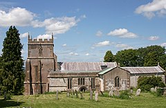
Ashbury, Oxfordshire
| Ashbury | |
|---|---|
 St Mary the Virgin parish church |
|
 War memorial and public green with neighbouring houses. |
|
| Ashbury shown within Oxfordshire | |
| Area | 22.47 km2 (8.68 sq mi) |
| Population | 506 (2011 Census) |
| • Density | 23/km2 (60/sq mi) |
| OS grid reference | SU2685 |
| Civil parish |
|
| District | |
| Shire county | |
| Region | |
| Country | England |
| Sovereign state | United Kingdom |
| Post town | Swindon |
| Postcode district | SN6 |
| Dialling code | 01793 |
| Police | Thames Valley |
| Fire | Oxfordshire |
| Ambulance | South Central |
| EU Parliament | South East England |
| UK Parliament | |
| Website | Ashbury Parish News |
Ashbury is a village and large civil parish at the upper end (west) of the Vale of White Horse. It was part of Berkshire until the 1974 boundary changes transferred it to Oxfordshire. The village is centred 7 miles (11 km) east of Swindon in neighbouring Wiltshire. The parish includes the hamlets of Idstone and Kingstone Winslow. The 2011 Census recorded the parish's population as 506.
The parish rises from an alluvial plain in the north to an escarpment in the south. Soils are shallow on the chalkland of the North Wessex Downs Area of Outstanding Natural Beauty in the southern part of the parish. Five small tributaries of the north-flowing Cole rise in the central strip of the parish and flow northwards.
The Neolithic burial site of Wayland's Smithy is in the parish 1 mile (1.6 km) east of the village.
The earliest known record of Ashbury is from AD 840, when King Æthelwulf of Wessex granted land at Aisshedoune to his minister Duda. In subsequent charters the toponym evolved as Æcesbyrig in AD 856, Aysshedoune in AD 947, Æcesburuh in AD 953 and 960 and Eissesberie in the 11th century.
After AD 953 the manor of Ashbury was granted to Glastonbury Abbey, which then held it until the Dissolution of the Monasteries in 1539. A deer park was established for the Abbey in the south of the parish. It is bounded by an ancient embankment enclosing a rounded area characteristic of Medieval parks. It may equate to the Aysshen Wood recorded in a terrier of the parish in 1519 as covering 415 acres (168 ha). The former deer park is now the Upper Wood of Ashdown Park.
...
Wikipedia

