Asakawa, Fukushima
|
Asakawa 浅川町 |
|||
|---|---|---|---|
| Town | |||

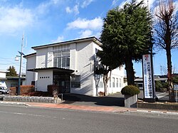
Asakawa Town Hall
|
|||
|
|||
 Location of Asakawa in Fukushima Prefecture |
|||
| Coordinates: 37°04′59″N 140°25′01″E / 37.08306°N 140.41694°ECoordinates: 37°04′59″N 140°25′01″E / 37.08306°N 140.41694°E | |||
| Country | Japan | ||
| Region | Tōhoku | ||
| Prefecture | Fukushima Prefecture | ||
| District | Ishikawa District | ||
| Area | |||
| • Total | 37.43 km2 (14.45 sq mi) | ||
| Population (November 2014) | |||
| • Total | 6,604 | ||
| • Density | 176/km2 (460/sq mi) | ||
| Time zone | Japan Standard Time (UTC+9) | ||
| - Tree | Pinus densiflora | ||
| - Flower | Pecteilis radiata | ||
| - Bird | Azure-winged magpie | ||
| Phone number | 0247-36-4121 | ||
| Address | 112-15 Setoyachi, Asakawa, Asakawa-machi, Ishikawa-gun, Fukushima-ken 963-6204 | ||
| Website | Official HP | ||
Asakawa (浅川町 Asakawa-machi?) is a town located in Ishikawa District, Fukushima Prefecture, in northern Honshū, Japan. As of November 2014, the town had an estimated population of 6,604 and a population density of 176 persons per km². The total area was 37.43 km².
Asakawa is located in southern portion of Fukushima prefecture.
The area of present-day Asakura was part of ancient Mutsu Province. The area was tenryō territory under direct control of the Tokugawa Shogunate during the Edo period. After the Meiji Restoration, it was organized as part of Nakadōri region of Iwaki Province.
The village of Asakura was formed on April 1, 1889 with the creation of the municipalities system. It was raised to town status on August 1, 1935. The town expanded on October 1, 1950 by the annexation of the neighboring village of Yamashiraishi.
The economy of Asakura is primarily based on agriculture.
...
Wikipedia


