Arrochar, Argyll
Arrochar
|
|
|---|---|
 Arrochar with Ben Lomond behind, taken from the path to The Cobbler. |
|
| Arrochar shown within Argyll and Bute | |
| OS grid reference | NN 29700 04300 |
| Council area |
|
| Lieutenancy area |
|
| Country | Scotland |
| Sovereign state | United Kingdom |
| Post town | Alexandria |
| Postcode district | G83 |
| Dialling code | 01301 |
| EU Parliament | Scotland |
| UK Parliament |
|
| Scottish Parliament |
|
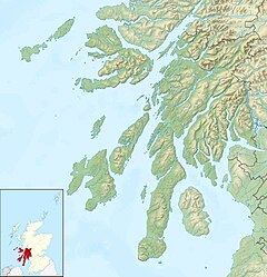
Arrochar; (/ˈærəxər/ ARR-ə-khər; Scottish Gaelic: An t-Àrchar or An Tairbeart Iar) is a village located near the head of Loch Long, on the Cowal peninsula in Argyll and Bute, Scottish Highlands. The village is within the Loch Lomond and The Trossachs National Park.
Historically in Dunbartonshire, it is overlooked by a group of mountains called the Arrochar Alps, and in particular by the distinctive rocky summit of the Cobbler. It enjoys good communications as it is at the junction of the A83 and A814 roads and is served by Arrochar and Tarbet railway station. In addition the A82 road runs through Tarbet two miles to the east.
For over five centuries this area, the feudal barony of Arrochar, was held by the chiefs of Clan MacFarlane and before them by their ancestors the barons of Arrochar. The family is Celtic in the male line and native to their Highland homeland of tall peaks and deep lochs just above the waist of Scotland. The settlement was a key target for Viking raiders who took their boats 2 miles overland to Tarbet to attack the unprotected inland settlements at Loch Lomond before their defeat in 1263 at the battle of Largs.
...
Wikipedia

