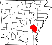
Arkansas County, Arkansas
| Arkansas County, Arkansas | |
|---|---|
 Location in the U.S. state of Arkansas |
|
 Arkansas's location in the U.S. |
|
| Founded | December 13, 1813 |
| Named for | Arkansas tribe |
| Seat |
Stuttgart (north district); De Witt (south district) |
| Largest city | Stuttgart |
| Area | |
| • Total | 1,034 sq mi (2,678 km2) |
| • Land | 989 sq mi (2,561 km2) |
| • Water | 45 sq mi (117 km2), 4.4% |
| Population (est.) | |
| • (2015) | 18,433 |
| • Density | 19/sq mi (7/km²) |
| Congressional district | 1st |
| Time zone | Central: UTC-6/-5 |
Coordinates: 34°16′27″N 91°23′02″W / 34.27417°N 91.38389°W
Arkansas County is a county located in the U.S. state of Arkansas. As of the 2010 census, the population was 19,019. The county has two county seats, De Witt and Stuttgart. The first of the state's 75 present-day counties to be created, Arkansas County was formed on December 13, 1813, when this area was part of the Missouri Territory, and is named after the Arkansas Indian tribe.
Arkansas County is one of seven current-day counties in the United States to share the same name as the state they are located in (the other six counties are Hawaii County, Idaho County, Iowa County, New York County, Oklahoma County, and Utah County).
According to the U.S. Census Bureau, the county has a total area of 1,034 square miles (2,680 km2), of which 989 square miles (2,560 km2) is land and 45 square miles (120 km2) (4.4%) is water. It is the third-largest county in Arkansas by area.
...
Wikipedia
