Arizpe, Sonora
|
Arizpe Arispe (alternate spelling) |
|
|---|---|

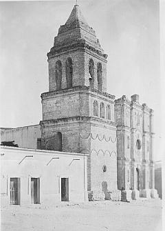
Nuestra Señora de la Asunción de Arizpe, built ca. 1756
|
|
| Coordinates: 30°19′51″N 110°10′9″W / 30.33083°N 110.16917°WCoordinates: 30°19′51″N 110°10′9″W / 30.33083°N 110.16917°W |
Arizpe (or Arispe) is a small town in Arizpe Municipality in the north of the Mexican state of Sonora. It is located at 30°20'"N 110°09'"W. The area of the municipality is 2,806.78 sq.km. The population in 2005 was 2,959 of which 1,743 lived in the municipal seat as of the 2000 census.
The region of Arizpe was occupied by the Opata people. The name Arizpe is a Basque word "Aritzpe"((H)Aritz meaning Oak and Pe meaning under) and translates to "Under the Oaks".
Arizpe was founded in 1646 by the Jesuit missionary Jerónimo de la Canal, with one of the Spanish missions in the Sonoran Desert.
In 1776 Arizpe was made the capital of the Spanish colonial Comandancia y Capitanía General de las Provincias Internas. As the capital, Arizpe became a city by the end of the eighteenth century, the first in the Sonora region.
The Provincias Internas had jurisdiction over the provinces of: Sonora and Sinaloa (present day Sonora and Sinaloa, Nueva Vizcaya (present day Durango and Chihuahua), Las Californias (present day Baja California Peninsula and California), Nueva Vizcaya and Santa Fe de Nuevo México (present day New Mexico), Los Tejas (present day Texas), New Kingdom of León (present day Nuevo Leon), Nuevo Santander (present day Tamaulipas and southern Texas), and Coahuila in Nueva Extremadura (present-day Coahuila and Texas south of Nueces River).
...
Wikipedia
