Argyle, Nova Scotia
| Argyle | |||
|---|---|---|---|
| District municipality | |||
| Municipality of the District of Argyle | |||
|
|||
| Motto: Industry | |||
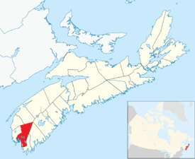
 Location of the Municipality of the District of Argyle |
|||
| Country |
|
||
| Province |
|
||
| County | Yarmouth | ||
| Incorporated | April 17, 1879 | ||
| Electoral Districts Federal |
West Nova |
||
| Provincial | Argyle | ||
| Government | |||
| • Type | Argyle Municipal Council | ||
| • Municipal Seat | Tusket | ||
| • Warden | Aldric d'Entremont | ||
| • Deputy Warden | Calvin d'Entremont | ||
| • Councillors |
List of Members
|
||
| • MLA MP |
Chris d'Entremont (PC) Colin Fraser (L) |
||
| Area | |||
| • Land | 1,528.17 km2 (590.03 sq mi) | ||
| Population (2016) | |||
| • Total | 7,899 | ||
| • Density | 5.2/km2 (13/sq mi) | ||
| • Change 2011-16 |
|
||
| Time zone | AST (UTC-4) | ||
| • Summer (DST) | ADT (UTC-3) | ||
| Area code(s) | 902 | ||
| Dwellings | 3,821 | ||
| Median Income* | $49,898 CDN | ||
| Website | Official website | ||
|
|||
Argyle, officially named the Municipality of the District of Argyle, is a district municipality in Yarmouth County, Nova Scotia. Statistics Canada classifies the district municipality as a municipal district.
The district municipality occupies the eastern portion of the county and is one of three municipal units - the other two being the Town of Yarmouth and the Municipality of the District of Yarmouth. Argyle is a bilingual community, in which native speakers of English and French each account for about half of the population. As of 2016, 60% of the population speaks both French and English; one of the highest rates of bilingualism in Canada.
Originally inhabited by the Mi'kmaq, it was called "Bapkoktek". In 1766, after his service in the French and Indian Wars, Lt. Ranald MacKinnon was given a land grant of 2,000 acres (8.1 km2). He called it Argyle (Argyll) because he was reminded of his previous home in the Highlands of Scotland. The township was granted in 1771.
In the 2016 Census of Population conducted by Statistics Canada, the Municipality of the District of Argyle recorded a population of 7,899 living in 3,362 of its 3,821 total private dwellings, a change of −4.3% from its 2011 population of 8,252. With a land area of 1,528.17 km2 (590.03 sq mi), it had a population density of 5.2/km2 (13.4/sq mi) in 2016.
Education:
Unemployment rate:
Average house value:
Coordinates: 43°48′00″N 65°51′00″W / 43.800°N 65.850°W
...
Wikipedia


