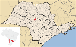
Arealva
| Arealva | |
|---|---|
| Municipality | |
 Location in São Paulo state |
|
| Location in Brazil | |
| Coordinates: 22°1′43″S 48°54′40″W / 22.02861°S 48.91111°WCoordinates: 22°1′43″S 48°54′40″W / 22.02861°S 48.91111°W | |
| Country |
|
| Region | Southeast Region |
| State | São Paulo |
| Area | |
| • Total | 505 km2 (195 sq mi) |
| Population (2015) | |
| • Total | 8,351 |
| • Density | 17/km2 (43/sq mi) |
| Time zone | BRT/BRST (UTC-3/-2) |
Arealva is a city in the state of São Paulo in Brazil. The population is 8,351 (2015 est.) in an area of 505 km². The elevation is 445 m.
The Bauru-Arealva Airport (official name Moussa Nakhl Tobias State Airport) located at Arealva also serves the adjoining city of Bauru.
...
Wikipedia

