Ardnaree
|
Ballina Béal an Átha
|
||
|---|---|---|
| Town | ||

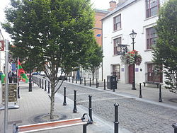
Pearse Street, Ballina
|
||
|
||
| Location in Ireland | ||
| Coordinates: 54°07′00″N 9°10′00″W / 54.1167°N 9.1667°WCoordinates: 54°07′00″N 9°10′00″W / 54.1167°N 9.1667°W | ||
| Country | Ireland | |
| Province | Connacht | |
| County | County Mayo | |
| Elevation | 7 m (23 ft) | |
| Population (2011) | 10,361 | |
| Irish Grid Reference | G240192 | |
Ballina (/ˌbælɪˈnɑː/; Irish: Béal an Átha, meaning "mouth of the ford") is a town in north County Mayo, Ireland. It lies at the mouth of the River Moy near Killala Bay, in the Moy valley and Parish of Kilmoremoy, with the Ox Mountains to the east and the Nephin Beg mountains to the west. The town occupies two baronies; Tirawley on the west bank of the Moy River, and Tireragh, a barony within the County of Sligo, on its east banks.
The population of Ballina is 10,361 according to the 2011 census (including environs it is 11,086) and is Mayo's largest urban area.
According to Encyclopædia Britannica the first signs of settlement on the site of the town dates from around 1375 when an Augustinian friary was founded. Belleek, now part of the town, pre-dates the town’s formation, and can be dated back to the late 15th century, or early 16th century. However, what is now known as Belleek Castle was built in 1831. Ballina was officially established as a town in 1723 by O'Hara, Lord Tyrawley.
The Dolmen of the Four Maols is located on 'Primrose Hill' behind Ballina's Railway Station. The dolmen dates from c2,000 B.C. and is sometimes called locally the 'Table of the Giants'. Legend has it that the dolmen is the burial place of the four Maols. The four Maols murdered Ceallach, a 7th-century Bishop of Kilmoremoy and were quartered at Ardnaree - the Hill of Executions. Tradition says that their bodies were buried under the dolmen.
The Belleek estate once occupied lands from the Moy River to the modern-day Killala Road. This included part of the "Old French Road" which General Humbert marched on from Killala, and beside part of which in the Killala Road-Belleek area was Belleek’s reservoir – presumably destroyed in the construction of Coca-Cola’s "Ballina Beverages" factory; the Old French Road is now closed off at that point.
...
Wikipedia


