Arch, Switzerland
| Arch | ||
|---|---|---|

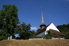
Arch village Reformed Church
|
||
|
||
| Coordinates: 47°10′N 7°26′E / 47.167°N 7.433°ECoordinates: 47°10′N 7°26′E / 47.167°N 7.433°E | ||
| Country | Switzerland | |
| Canton | Bern | |
| District | Seeland | |
| Area | ||
| • Total | 6.37 km2 (2.46 sq mi) | |
| Elevation | 450 m (1,480 ft) | |
| Population (Dec 2015) | ||
| • Total | 1,540 | |
| • Density | 240/km2 (630/sq mi) | |
| Postal code | 3296 | |
| SFOS number | 0381 | |
| Surrounded by | Bettlach (SO), Bibern (SO), Grenchen (SO), Leuzigen, Rüti bei Büren | |
| Website |
www SFSO statistics |
|
Arch is a municipality in the Seeland administrative district in the canton of Bern in Switzerland. It is also a church parish of the Swiss Reformed Church.
The first historical mention of the town was in 1236 as Archo.
The earliest traces of human settlements around Arch include scattered neolithic items and Hallstatt culture grave mounds. During the Roman era Arch was on the Petinesca-Salodurum (Solothurn) road. During the High Middle Ages an earthen and wooden castle stood on the Schlosshubel or Maierislihubel. Originally it was part of the Herrschaft of Strassberg but in 1388 it was acquired by Bern. In 1393 it became part of the newly created bailiwick of Buren.
The village church was originally a romanesque structure which was built in the 10th century. The building was first mentioned in 1275. In 1528 it switched to the new religion during the Protestant Reformation, and two years later the choir was rebuilt.
In 1561, a ferry across the Aare was set up, though the village remained primarily agricultural. In the 19th century improving agricultural technology reduced the demand for agricultural workers and left many in the village without jobs. However, the Jura water correction of the late 19th century opened up new farming land. Further land reclamation projects took place in 1918-26 and 1980. The 1980 project also built the A5 motorway which helped connect the village with surrounding towns. The first bridge over the Aare at Arch was built in 1874. It was followed two years later with the Solothurn-Lyss railway line. The bridge and railroad opened up new job opportunities, first in the watch industry and later in various industries. During the 20th century several factories opened in Arch including gravel mining and metal processing (1942), a machinery factory (1966), construction equipment (1946), and suppliers to the watch industry. With all the factories, many workers commuted into Arch for work from the surrounding villages. Arch grew into a regional center and in 1972 the secondary school for the Ruti-Arch-Leuzigen district was built in Arch.
...
Wikipedia


