Arabi, Georgia
| Arabi, Georgia | |
|---|---|
| Town | |
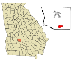
 Location in Crisp County and the state of Georgia |
|
| Coordinates: 31°50′1″N 83°44′6″W / 31.83361°N 83.73500°WCoordinates: 31°50′1″N 83°44′6″W / 31.83361°N 83.73500°W | |
| Country | United States |
| State | Georgia |
| County | Crisp |
| Area | |
| • Total | 6.4 sq mi (16.6 km2) |
| • Land | 6.3 sq mi (16.3 km2) |
| • Water | 0.1 sq mi (0.3 km2) |
| Elevation | 440 ft (134 m) |
| Population (2010) | |
| • Total | 586 |
| • Density | 93/sq mi (35.8/km2) |
| Time zone | Eastern (EST) (UTC-5) |
| • Summer (DST) | EDT (UTC-4) |
| ZIP code | 31712 |
| Area code(s) | 229 |
| FIPS code | 13-02564 |
| GNIS feature ID | 0331047 |
| Website | cityofarabi |
Arabi is a town in Crisp County, Georgia, United States. As of the 2010 census, it had a population of 586.
Arabi is located in southern Crisp County at 31°50′1″N 83°44′6″W / 31.83361°N 83.73500°W (31.833473, -83.734912).U.S. Route 41 passes through the center of the town as Bedgood Avenue, leading north 9 miles (14 km) to Cordele, the county seat, and south 10 miles (16 km) to Ashburn. Interstate 75 passes through the eastern side of the town, with access from Exit 92, and leads north 73 miles (117 km) to Macon and south 75 miles (121 km) to Valdosta.
According to the United States Census Bureau, Arabi has a total area of 6.4 square miles (16.6 km2), of which 6.3 square miles (16.3 km2) is land and 0.12 square miles (0.3 km2), or 1.81%, is water.
As of the census of 2000, there were 456 people, 185 households, and 120 families residing in the town. The population density was 100.9 people per square mile (39.0/km²). There were 204 housing units at an average density of 45.1 per square mile (17.4/km²). The racial makeup of the town was 74.78% White, 24.34% African American and 0.88% Asian.
...
Wikipedia
