Aqtöbe
|
Aktobe Ақтөбе (Kazakh) |
||
|---|---|---|
| City | ||
|
||
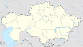
| Location in Kazakhstan | ||
| Coordinates: 50°17′0″N 57°10′0″E / 50.28333°N 57.16667°E | ||
| Country | Kazakhstan | |
| Region | Aktobe Region | |
| Founded | 1869 | |
| Government | ||
| • Akim (mayor) | Bekbol Sagyn | |
| Area | ||
| • City | 400 km2 (200 sq mi) | |
| Elevation | 219 m (719 ft) | |
| Population (2013-01-01) | ||
| • City | 371 546 | |
| • Metro | 420,778 | |
| Time zone | UTC+5 (UTC+5) | |
| Postal code | 030001 | |
| Area code(s) | +7 7132 | |
| Vehicle registration | D | |
| Website | http://www.akimataktobe.gov.kz/ | |
Aktobe (Kazakh: Ақтөбе, Aqtöbe) is a city on the Ilek River in Kazakhstan. It is the administrative center of Aktobe Region. In 2013, it had a population of 371,546 people.
The name "Aktobe" comes from Kazakh "ақ" (white) and "төбе" (hill); the name is a reference to the heights on which the original 19th century settlement was located.
Until 1999 it was officially known as Aktyubinsk (Russian: Актюбинск). The former name is still commonly used in the Russian language, and by Russians in Kazakhstan.
The territory of modern-day Aktobe Region has seen the rise and fall of many Central Asian cultures and empires. The region figured prominently in the history of the Kazakh "Little Horde". The Kazakh warlord Eset Batyr based his campaigns against the Dzungars from this area. His mausoleum is located 35 kilometres (22 miles) to the south of Aktobe city. Abulkhair Khan (1693–1748) was also based in this region.
In March 1869, a Russian military fort with a garrison of 300 was built at the confluence of the Kargala and Ilek Rivers, along the Orenburg - Kazalinsk caravan route. From that period onward, Slavic settlers began to migrate to the region in order to farm, and very soon, neighbourhoods were built around the fort. In 1874 the fort was expanded in size, and streets were laid out to and from the fort's gate. In 1891 the settlement was labelled a district city, and officially named Aktyubinsk.
In the late 19th and early 20th centuries the settlement rapidly expanded in size. While the 1889 population was listed as 2,600, by 1909 the population had increased more than four times to 10,716 official residents. The physical characteristics of the city had developed as well, and by the turn of the century the city had two churches, a seminary, a Tatar mosque, a Russian-Kyrgyz boys' school and girls' school, a clinic, a bank, a post office, a city park, a cinema and two mills. The Trans-Aral Railway was extended through the city in 1901. In the years leading up to World War I, industry began to develop in the town, including the construction of an electric factory, a brick factory and the establishment of an annual trade fair.
...
Wikipedia


