Apayao (province)
| Apayao | ||
|---|---|---|
| Province | ||
| Province of Apayao | ||
|
||
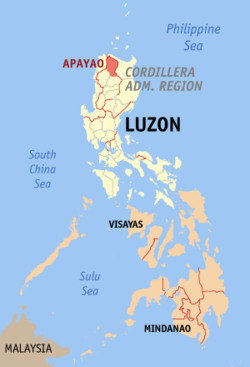
 Location in the Philippines |
||
| Coordinates: 17°45′N 121°15′E / 17.75°N 121.25°ECoordinates: 17°45′N 121°15′E / 17.75°N 121.25°E | ||
| Country | Philippines | |
| Region | Cordillera Administrative Region (CAR) | |
| Founded | February 14, 1995 | |
| Capital | Kabugao* | |
| Government | ||
| • Type | Sangguniang Panlalawigan | |
| • Governor | Elias C. Bulut, Jr. (Liberal Party) | |
| • Congresswoman | Eleanor C. Bulut-Begtang (Nationalist People's Coalition) | |
| • Vice Governor | Hector Pascua (Liberal Party) | |
| Area | ||
| • Total | 4,413.35 km2 (1,704.00 sq mi) | |
| Area rank | 27th out of 81 | |
| Highest elevation (Mount Lambayo) | 1,386 m (4,547 ft) | |
| Population (2015 census) | ||
| • Total | 119,184 | |
| • Rank | 78th out of 81 | |
| • Density | 27/km2 (70/sq mi) | |
| • Density rank | 81st out of 81 | |
| Divisions | ||
| • Independent cities | 0 | |
| • Component cities | 0 | |
| • Municipalities | ||
| • Barangays | 133 | |
| • Districts | Lone district of Apayao | |
| Time zone | PHT (UTC+8) | |
| ZIP code | 3807–3814 | |
| IDD : area code | +63 (0)74 | |
| ISO 3166 code | PH-APA | |
| Spoken languages | ||
| Website | www |
|
| * Kabugao is the officially-recognized capital and seat of government, although the province carries out many of its operations in a new government center established in Luna. | ||
Apayao (Ilocano: Probinsya ti Apayao, Filipino: Lalawigan ng Apayao) is a landlocked province in the Philippines in the Cordillera Administrative Region in Luzon. Its capital town is Kabugao.
The province borders Cagayan to the north and east, Abra and Ilocos Norte to the west, and Kalinga to the south. Prior to 1995, Kalinga and Apayao comprised a single province named Kalinga-Apayao, which was partitioned to better service the needs of individual ethnic groups.
With a population of 119,184 (as of the 2015 census) covering an area of 4,413.35 square kilometres (1,704.00 sq mi), Apayao is the least densely-populated province in the Philippines.
Although Apayao, which was then part of Cagayan, was among the earliest areas penetrated by the Spaniards in the Cordilleras, the region, inhabited by the Isneg tribe, remained largely outside Spanish control until late in the 19th century. As early as 1610, the Dominican friars established a mission in what is now the town of Pudtol. In 1684, the friars again made attempts to convert the people and established a church in what is now Kabugao.
The Spanish authorities were then able to establish in Cagayan the comandancias of Apayao and Cabugaoan in 1891, which covered the western and eastern portions of what is now Apayao. The comandancias, however, failed to bring total control and the Spanish government only maintained a loose hold over the area.
...
Wikipedia

