Aoba-ku, Yokohama
|
Aoba 青葉区 |
||
|---|---|---|
| Ward | ||
| Aoba Ward | ||
|
||
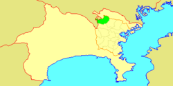
 Location of Aoba in Kanagawa |
||
| Coordinates: 35°33′10″N 139°32′14″E / 35.55278°N 139.53722°ECoordinates: 35°33′10″N 139°32′14″E / 35.55278°N 139.53722°E | ||
| Country | Japan | |
| Region | Kantō | |
| Prefecture | Kanagawa | |
| City | Yokohama | |
| Area | ||
| • Total | 35.14 km2 (13.57 sq mi) | |
| Population (February 2010) | ||
| • Total | 302,643 | |
| • Density | 8,610/km2 (22,300/sq mi) | |
| Time zone | Japan Standard Time (UTC+9) | |
| - Tree | Yamazakura | |
| - Flower | Nashi Pear | |
| Address | 31-4 Ichigao-chō, Aoba-ku Yokohama-shi, Kanagawa-ken 225-0024 |
|
| Website | Aoba Ward Office | |
Aoba-ku (青葉区?) is one of the 18 wards of the city of Yokohama in Kanagawa Prefecture, Japan. As of 2010, the ward had an estimated population of 302,643 and a density of 8,610 persons per km². The total area was 35.14 km².
Aoba is located in eastern Kanagawa Prefecture, and in the northwest corner of the city of Yokohama. The area is largely flatland, with scattered small hills.
The area around present-day Aoba Ward was formerly part of Tsutsuki District in Musashi Province. During the Edo period, it was a rural region classified as tenryō territory controlled directly by the Tokugawa shogunate, but administered through various hatamoto. After the Meiji Restoration, the area became part of the new Kanagawa Prefecture in 1868. In the cadastral reform of April 1, 1889, the area was divided into the villages of Tana, Nakazato and Yamauchi in Tsuzuki District (都筑郡田奈村, 中里村, 山内村 Tsuzuki-gun Tana-mura, Nakazato-mura, Yamauchi-mura?). During the Meiji period, the area was a center for sericulture. On April 1, 1939, the three villages within Tsutsuki District were annexed by the neighboring city of Yokohama, becoming part of Kōhoku-ku.
...
Wikipedia


