Anthony Henday Drive
| Anthony Henday Drive | ||||
|---|---|---|---|---|
| Highway 216 | ||||

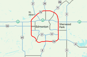
Anthony Henday Drive highlighted in red
|
||||
| Route information | ||||
| Maintained by Volker Stevin, Carmacks, Lafarge | ||||
| Length: | 77.23 km (47.99 mi) | |||
| History: | 1990 (construction begins) 1992 (first segment open) 2016 (ring completed) |
|||
| Component highways: |
|
|||
| Major junctions | ||||
| Ring road around Edmonton | ||||
| Location | ||||
| Specialized and rural municipalities: |
Strathcona County | |||
| Major cities: | Edmonton, St. Albert, Sherwood Park | |||
| Highway system | ||||
|
Provincial highways in Alberta
|
||||
Provincial highways in Alberta
Anthony Henday Drive (Highway 216) is a 77-kilometre (48 mi) freeway that encircles Edmonton, Alberta, Canada. It is a heavily travelled commuter and truck bypass route, with the southwest quadrant serving as a portion of the CANAMEX Corridor linking Canada to the United States and Mexico. Henday is one of the busiest roads in Western Canada, carrying over 105,000 vehicles per day near West Edmonton Mall. Rush hour congestion is common in southwest Edmonton where traffic levels have outpaced Alberta Transportation estimates by a significant margin due to rapid suburban development.
Calgary Trail in south Edmonton is designated as the starting point of the ring, with exit numbers increasing clockwise across the North Saskatchewan River to the Cameron Heights neighbourhood, then north past Whitemud Drive, Stony Plain Road and Yellowhead Trail to St. Albert. It continues east past 97 Street to Manning Drive, then south across the North Saskatchewan River a second time. Entering Strathcona County, it again crosses Yellowhead Trail before passing Sherwood Park and Whitemud Drive. Continuing south to Highway 14, the road re-enters southeast Edmonton and turns west to complete the ring.
...
Wikipedia

