Annanhead Hill
| Annanhead Hill | |
|---|---|

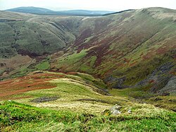
Annanhead Hill above Devils Beef Tub
|
|
| Highest point | |
| Elevation | 478 m (1,568 ft) |
| Coordinates | 55°24′15″N 3°29′19″W / 55.40417°N 3.48861°WCoordinates: 55°24′15″N 3°29′19″W / 55.40417°N 3.48861°W |
| Geography | |
| Location | 9 km north of Moffat |
| Parent range | Moffat Hills |
| OS grid | NT 05834 13251 |
Annanhead Hill is a 478-metre (1,568 ft) summit in the Moffat Hills of Scotland. It lies on the boundary between the Scottish Borders and Dumfries and Galloway, 9 kilometres (5.6 mi) north of Moffat, in the Southern Uplands.
Annanhead is one of four hills encircling the Devil's Beef Tub, the headwaters of River Annan.
The hill is crossed by Annandale Way hiking trail designated in 2009.
...
Wikipedia
