Anjaw District
| Anjaw district | |
|---|---|
| District of Arunachal Pradesh | |
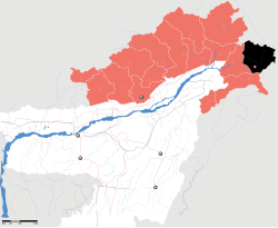
 Location of Anjaw district in Arunachal Pradesh |
|
| Country | India |
| State | Arunachal Pradesh |
| Headquarters | Hawai, Arunachal Pradesh |
| Government | |
| • Lok Sabha constituencies | Arunachal East |
| • Assembly seats | Hayuliang |
| Area | |
| • Total | 6,190 km2 (2,390 sq mi) |
| Population (2011) | |
| • Total | 21,089 (2,011) |
| Demographics | |
| • Literacy | 59.4% |
| • Sex ratio | 805 |
| Website | Official website |
Anjaw District (Pron:/ˈændʒɔ:/) is an administrative district in the state of Arunachal Pradesh in north-east India. It is a newly created district, having been split from Lohit district on 16 February 2004 under the Arunachal Pradesh Re-organization of Districts Amendment Bill. The district borders China on the north. Hawai, at an altitude of 1296 m above sea level, is the district headquarters, located on the banks of the Lohit River, a tributary of the Brahmaputra River. It is the easternmost district in India. The easternmost community in Anjaw is the village of Dong.
Anjaw is the second least populous district in India (out of 640).
The main rivers are the following:
The 2,000-kilometre-long (1,200 mi) proposed Mago-Thingbu to Vijaynagar Arunachal Pradesh Frontier Highway along the McMahon Line, (will intersect with the proposed East-West Industrial Corridor Highway) and will pass through this district, alignment map of which can be seen here and here.
The main crops are maize, millet, rice, beans, cardamom, orange, pears, plum, and apple.
There is one Arunachal Pradesh Legislative Assembly constituency located in this district: Hayuliang. It is part of the Arunachal East Lok Sabha constituency.
...
Wikipedia
