Aniakchak National Monument
| Aniakchak National Monument and Preserve | |
|---|---|
|
IUCN category VI (protected area with sustainable use of natural resources)
|
|

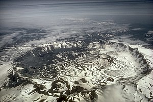
Aerial view of the caldera of Mount Aniakchak from the west
|
|
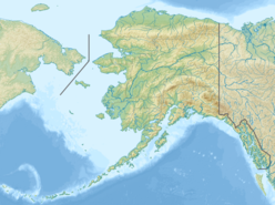
| Location | Lake and Peninsula Borough, Alaska, USA |
| Coordinates | 56°50′N 158°15′W / 56.833°N 158.250°WCoordinates: 56°50′N 158°15′W / 56.833°N 158.250°W |
| Area | 601,294 acres (2,433.35 km2) |
| Created | December 1, 1978 |
| Visitors | 19 (in 2012) |
| Governing body | National Park Service |
| Website | Aniakchak National Monument and Preserve |
| Designated | 1970 |
|
Aniakchak Bay Historic Landscape District
|
|
|
Alaska Heritage Resources Survey
|
|
| Location | Aniakchak National Monument and Preserve |
|---|---|
| Nearest city | Chignik, Alaska |
| Coordinates | 56°45′30″N 157°31′19″W / 56.75833°N 157.52194°W |
| Area | 2,100 acres (850 ha) |
| NRHP Reference # | 97000016 |
| AHRS # | SUT-016 |
| Added to NRHP | February 14, 1997 |
Aniakchak National Monument and Preserve is a U.S. National Monument and National Preserve, consisting of the region around the Aniakchak volcano on the Aleutian Range of south-western Alaska. The 601,294-acre (243,335 ha) monument is one of the least visited places in the National Park System due to its remote location and difficult weather. The area was proclaimed a National Monument on December 1, 1978, and established as a National Monument and Preserve on December 2, 1980. The National Monument encompasses 137,176 acres (55,513 ha) and the preserve 464,118 acres (187,822 ha). Visitation to Aniakchak is the lowest of all areas of the U.S. National Park System, according to the NPS, with only 134 documented recreational visits in 2014. Most visitors fly into Surprise Lake inside Aniakchak Crater, but the frequent fog and other adverse weather conditions make landing in the lake difficult. It is also possible to fly into the nearby village of Port Heiden and proceed overland to the Aniakchak Crater.
The core of the national monument lands encompasses the 6-mile (9.7 km) wide Aniakchak Crater. The high point on the caldera rim is Aniakchak Peak. The lake within the caldera, Surprise Lake, is the source of the Aniakchak River. Multiple streams and rivers within the caldera flow into Surprise Lake to form it. In addition to Surprise Lake, the other prominent feature inside the caldera is Vent Mountain, the site of the most recent (1931) eruption within the caldera. The preserve lands flank the monument on either side. Subsistence hunting is allowed in both the monument and preserve, and sport hunting is allowed in the preserve. The region was virtually unexplored until the 1920s, when exploration for oil brought reports of an un-described volcano. A moderate eruption in 1931 forming Vent Mountain resulted in significant publicity, spurring studies to declare the region a national monument. It was not until 1978 that a monument was proclaimed by President Jimmy Carter under the Antiquities Act. The monument and preserve were established within their final boundaries in 1980 with the passage of the Alaska National Interest Lands Conservation Act.
...
Wikipedia


