Anglezarke
| Anglezarke | |
|---|---|
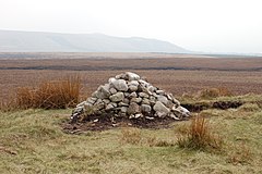
 The cairn on Round Loaf on Anglezarke Moor, looking towards Winter Hill |
|
| Anglezarke shown within Lancashire | |
| Population | 23 (2001) |
| OS grid reference | SD621171 |
| Civil parish |
|
| District | |
| Shire county | |
| Region | |
| Country | England |
| Sovereign state | United Kingdom |
| Post town | CHORLEY |
| Postcode district | PR6 |
| Dialling code | 01257 |
| Police | Lancashire |
| Fire | Lancashire |
| Ambulance | North West |
| EU Parliament | North West England |
| UK Parliament | |
Anglezarke is a sparsely populated civil parish in the Borough of Chorley in Lancashire, England. It is dominated by reservoirs that were built to supply water to Liverpool, and a large expanse of moorland with evidence of Bronze Age settlements. Popular with walkers and tourists, it lies in the West Pennine Moors in Lancashire, sandwiched between the moors of Withnell and Rivington, and is close to the towns of Chorley, Horwich and Darwen. At the 2001 census it had a population of 23. At the 2011 Census the population is included within Heapey civil parish.
Quarrying the hard millstone grit for building and paving, mining for lead and minerals, some small scale coal mining and hill farming were important in Anglezarke particularly from the 17th to the 19th centuries. There is no village, the settlement consisted of scattered farms with the hamlet of White Coppice close to the quarries. The area was subjected to depopulation after the reservoirs were built.
Anglezarke is derived from the Old Norse name Anlaf and the Old Norse erg, a 'hill pasture or shieling'. The elements together mean 'Anlaf's hill pasture'. The earliest spelling of the name was in 1202 when it was recorded as 'Andelevesarewe'. By 1225 this had become 'Anlavesargh', in 1351 'Anlasargh', and by 1559 'Anlazarghe'.
Human activity around Anglezarke can be traced to pre-historic times. Rushey Brow on Anglezarke Moor has a site of special archaeological interest, a working floor from the Mesolithic period, dated to 8th millennium BC. Other sites include Pikestones, a Neolithic burial cairn, and Round Loaf, a Bronze Age tumulus which can be seen from the route across Great Hill from White Coppice.
...
Wikipedia

