Anda, Pangasinan
| Anda | ||
|---|---|---|
| Municipality | ||

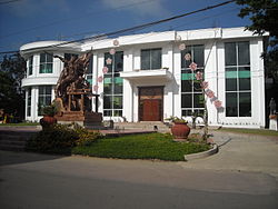
Municipal hall
|
||
|
||
 Map of Pangasinan showing the location of Anda |
||
| Location within the Philippines | ||
| Coordinates: 16°17′N 119°58′E / 16.283°N 119.967°ECoordinates: 16°17′N 119°58′E / 16.283°N 119.967°E | ||
| Country |
|
|
| Region | Ilocos (Region I) | |
| Province | Pangasinan | |
| District | 1st district of Pangasinan | |
| Founded | 1852 | |
| Barangays | 18 | |
| Government | ||
| • Mayor | Aldrin Caido Cerdan | |
| • Vice Mayor | Thelma Altre | |
| • Electorate | 23,235 voters (2016 election) | |
| Area | ||
| • Total | 74.55 km2 (28.78 sq mi) | |
| Population (2015 census) | ||
| • Total | 39,504 | |
| • Density | 530/km2 (1,400/sq mi) | |
| Time zone | PST (UTC+8) | |
| ZIP code | 2405 | |
| 015505000 | ||
| Dialing code | +63 (0)75 | |
| Income class | 3rd municipal income class | |
| Revenue | ₱ 6,596,755.99 (2016) | |
| Poverty incidence | 8.88 (2012) | |
| Website | www |
|
Anda is a 3rd class island municipality in the province of Pangasinan, Philippines. According to the 2015 census, it has a population of 39,504 people. The people of Anda generally speak Pangasinan, Bolinao, and Ilocano.
The municipality consists primarily of Cabarruyan Island (also known as Anda Island), as well as minor surrounding islets. Because of Anda's proximity near the Hundred Islands, a popular tourist destination for its caves and beaches, it is the so-called "Mother of the Hundred Islands."
Anda is politically subdivided into 18 barangays.
On the north-west portion of Lingayen Gulf lies a group of islands which comprise the territory of Anda.
Before the middle of the nineteenth century, the islands which comprise the municipality were uninhabited. Only occasionally did seafarers and fishermen use the coast as havens.
Andres de la Cruz Cacho, fondly called in Bolinao as Andales Kulayo, discovered a vast tract of land suitable for grazing and fertile lowlands, and an abundant spring for agriculture. It was he who brought families from the town of Bolinao aboard a big boat and dispersed them on the island of Cabarruyan in 1842. The spread of population was rapid.
On May 10, 1842, the pioneers landed on what is now the barrio of Dolaoan, put up a settlement, and chose San Miguel Arcangel as their Patron Saint. On May 25, 1842 they established Carot and Cabungan with Sta. Lucia as the common Saint of the two settlements.
In the first of June of same year, Tondol was founded. Sablig was settled in the middle of June. By the third week of June, Macaleeng was occupied.
No family was willing, to stay in Toritori at the time and so the place was bypassed. The settlers proceeded to Awile and Aruab (now Roxas) and by early July, they have established settlements in the area.
By August, Mal-Ong, Awag, Santa Rita, and San Nicolas were established. Within a period of only four months, May to August, 1842, the whole island of Cabarruyan was populated.
A steady stream of settlers followed the first pioneers and soon within a few years, the population was large enough to form a municipality.
...
Wikipedia


