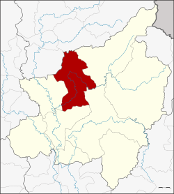
Amphoe Wat Bot
|
Wat Bot วัดโบสถ์ |
|
|---|---|
| Amphoe | |
 Amphoe location in Phitsanulok Province |
|
| Coordinates: 16°58′49″N 100°20′0″E / 16.98028°N 100.33333°ECoordinates: 16°58′49″N 100°20′0″E / 16.98028°N 100.33333°E | |
| Country | Thailand |
| Province | Phitsanulok |
| Area | |
| • Total | 1,326.210 km2 (512.053 sq mi) |
| Population (2005) | |
| • Total | 37,165 |
| • Density | 28.0/km2 (73/sq mi) |
| Time zone | ICT (UTC+7) |
| Postal code | 65160 |
| Geocode | 6507 |
Wat Bot (Thai: วัดโบสถ์) is a district (amphoe) in the northern part of Phitsanulok Province, northern Thailand.
Tambon Wat Bot was separated from the Phrom Phiram District and created as a minor district (king amphoe) on 1 January 1948. It was upgraded to a full district on 6 June 1956. The present district office was opened on 4 July 1991.
Neighboring districts are (from the east clockwise) Chat Trakan, Wang Thong, Mueang Phitsanulok, Phrom Phiram of Phitsanulok Province, Phichai and Thong Saen Khan of Uttaradit Province.
Wat Bot lies within the Nan Basin, which is part of the Chao Phraya Watershed. The Khwae Noi River flows through Wat Bot District.
Portions of Wat Bot are part of the Khwae Noi National Reserved Forest, which was recently made part of Kaeng Chet Khwae National Park.
The district is divided into six sub-districts (tambon), which are further subdivided into 61 villages (muban). The township (thesaban tambon) Wat Bot covers parts of tambon Wat Bot, Tha Ngam and Thothae. There are a further six tambon administrative organizations (TAO).
...
Wikipedia
