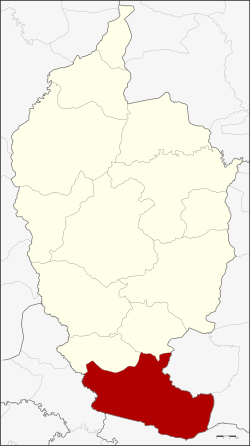
Amphoe Phayakkhaphum Phisai
|
Phayakkhaphum Phisai พยัคฆภูมิพิสัย |
|
|---|---|
| Amphoe | |
 Amphoe location in Maha Sarakham Province |
|
| Coordinates: 15°30′59″N 103°11′37″E / 15.51639°N 103.19361°ECoordinates: 15°30′59″N 103°11′37″E / 15.51639°N 103.19361°E | |
| Country |
|
| Province | Maha Sarakham |
| Area | |
| • Total | 409.783 km2 (158.218 sq mi) |
| Population (2008) | |
| • Total | 88,124 |
| • Density | 214.5/km2 (556/sq mi) |
| Time zone | THA (UTC+7) |
| Postal code | 44110 |
| Geocode | 4408 |
Phayakkhaphum Phisai (Thai: พยัคฆภูมิพิสัย) is a district (Amphoe) of Maha Sarakham Province, northeastern Thailand.
Neighboring districts are (from the north clockwise) Yang Sisurat and Na Dun of Maha Sarakham Province, Pathum Rat and Kaset Wisai of Roi Et Province, Chumphon Buri of Surin Province, and Phutthaisong of Buriram Province.
The district is subdivided into 14 subdistricts (tambon), which are further subdivided into 227 villages (muban). Phayakkhaphum Phisai is a subdistrict municipality (thesaban tambon) which covers parts of the tambon Palan and Lan Sakae. There are further 14 Tambon administrative organizations (TAO).
Missing numbers are tambon which now form Yang Sisurat district.
...
Wikipedia
