Amphoe Phatthana Nikhom
|
Phatthana Nikhom พัฒนานิคม |
|
|---|---|
| Amphoe | |

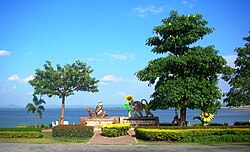
View of Pa Sak Cholasit Dam
|
|
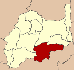
 Amphoe location in Lopburi Province |
|
| Coordinates: 14°51′21″N 100°59′24″E / 14.85583°N 100.99000°ECoordinates: 14°51′21″N 100°59′24″E / 14.85583°N 100.99000°E | |
| Country |
|
| Province | Lopburi |
| Seat | Phatthana Nikhom |
| Area | |
| • Total | 517.0 km2 (199.6 sq mi) |
| Population (2005) | |
| • Total | 61,306 |
| • Density | 118.6/km2 (307/sq mi) |
| Time zone | THA (UTC+7) |
| Postal code | 15140 |
| Geocode | 1602 |
Phatthana Nikhom (Thai: พัฒนานิคม, pronounced [pʰát.tʰā.nāː ní(ʔ).kʰōm]) is a district (amphoe) of Lopburi Province in central Thailand.
Neighboring districts are (from the north clockwise) Chai Badan and Tha Luang of Lopburi Province, Muak Lek, Wang Muang, Kaeng Khoi, Chaloem Phra Kiat and Phra Phutthabat of Saraburi Province, and Mueang Lop Buri and Khok Samrong of Lopburi.
The Pa Sak Cholasit Dam that stops the Pa Sak River is located in this district. Phatthana Nikhom is a favorite tourist place due to Sun Flower fields in the winter.
The district was created during the premiership of Field Marshal Plaek Phibunsongkhram.
The minor district (King Amphoe) was created on February 23, 1962, when the five tambon Di Lang, Manao Wan, Khok Salung, Chong Sarika and Nong Bua were split off from Mueang Lopburi district. It was upgraded to a full district on July 16, 1963.
...
Wikipedia
