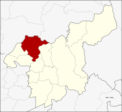
Amphoe Phra Phutthabat
|
Phra Phutthabat พระพุทธบาท |
|
|---|---|
| Amphoe | |
 Amphoe location in Saraburi Province |
|
| Coordinates: 14°43′32″N 100°47′43″E / 14.72556°N 100.79528°ECoordinates: 14°43′32″N 100°47′43″E / 14.72556°N 100.79528°E | |
| Country |
|
| Province | Saraburi |
| Seat | Phra Phutthabat |
| Area | |
| • Total | 287.1 km2 (110.8 sq mi) |
| Population (2000) | |
| • Total | 70.354 |
| • Density | 0.25/km2 (0.63/sq mi) |
| Time zone | THA (UTC+7) |
| Postal code | 18120 |
| Geocode | 1909 |
Phra Phutthabat (Thai: พระพุทธบาท) is a district (Amphoe) in Saraburi Province, Thailand.
The district is named after the Phra Phutthabat Temple. Another well-known temple in the district is Wat Tham Krabok, both as a Hmong refugee camp and as for its drug rehabilitation program.
Neighboring districts are (clockwise from the north) Mueang Lop Buri and Phattana Nikhom of Lopburi Province, and Chaloem Phra Kiat, Sao Hai, Ban Mo, Nong Don.
The district Phra Phuttabat is divided into 9 subdistricts (tambon), which are further divided into 67 villages (muban).
...
Wikipedia
