Amphoe Maha Chana Chai
|
Maha Chana Chai มหาชนะชัย |
|
|---|---|
| Amphoe | |
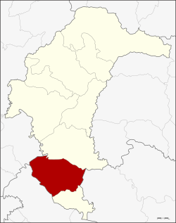
 Amphoe location in Yasothon Province |
|
| Coordinates: 15°31′57″N 104°14′33″E / 15.53250°N 104.24250°ECoordinates: 15°31′57″N 104°14′33″E / 15.53250°N 104.24250°E | |
| Country |
|
| Province | Yasothon |
| Seat | Fa Yat |
| Area | |
| • Total | 455.27 km2 (175.78 sq mi) |
| Population (2005) | |
| • Total | 58,670 |
| • Density | 128.9/km2 (334/sq mi) |
| Time zone | THA (UTC+7) |
| Postal code | 35130 |
| Geocode | 3506 |
Maha Chana Chai (Thai: มหาชนะชัย, pronounced [mā.hǎː t͡ɕʰā.náʔ t͡ɕʰāj]) is a district of Yasothon Province in northeastern Thailand.
In 1859, Prince Thao Puttakhamphun (ท้าวปุตตะคำพูน ราชบุตร) founded a new city in the vicinity of the village of Woen Chai (บ้านเวินชัย) beside the Chi River, which he named Mueang (city of) Han Chai Cham Na (เมืองหันชัยชำนะ translation unknown.) In 1863, King Rama IV renamed the town Mueang Maha Chana Chai (Triumphant Victory.)
The town became a district (amphoe) of Ubon Ratchathani Province in 1909, and on April 24, 1917 its name was changed to Amphoe Fa Yat (อำเภอฟ้าหยาด), because the district office was located in Fa Yat village, Fa Yat subdistrict. On April 7, 1939, the name was reverted to Amphoe Maha Chana Chai.
On March 1, 1972, when Yasothon Province was established, Maha Chana Chai was one of six districts reassigned to the new province.
Neighboring districts are (from the north clockwise) Kham Khuean Kaeo of Yasothon Province, Khueang Nai of Ubon Ratchathani Province, Kho Wang of Yasothon Province, Rasi Salai, Sila Lat of Sisaket Province, and Phanom Phrai of Roi Et Province.
...
Wikipedia
