Yasothon Province
|
Yasothon ยโสธร |
|
|---|---|
| Province | |
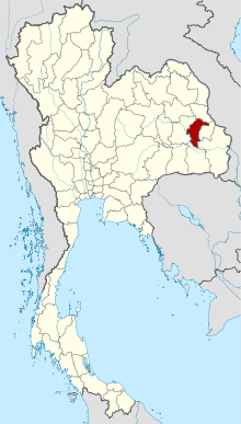
 Map of Thailand highlighting Yasothon Province |
|
| Country |
|
| Capital | Yasothon |
| Government | |
| • Governor | Buntham Loetsukhikasem (since October 2015) |
| Area | |
| • Total | 4,161.7 km2 (1,606.8 sq mi) |
| Area rank | Ranked 54th |
| Population (2014) | |
| • Total | 540,211 |
| • Rank | Ranked 44th |
| • Density rank | Ranked 29th |
| Time zone | ICT (UTC+7) |
| ISO 3166 code | TH-35 |
Yasothon (Thai: ยโสธร, pronounced [já.sǒː.tʰɔ̄ːn]) is a province (changwat) of Thailand, in the northeast on the Chi River. The province was established by the revolutionary council of Field Marshal Thanom Kittikachorn, after its which came into force on 3 March 1972.
Neighboring provinces are (from north clockwise) Mukdahan, Amnat Charoen, Ubon Ratchathani, Sisaket, and Roi Et.
The northern part of the province are plains with low hills, while the southern part is the river lowland of the River Chi, with ponds and swamps.
Yasothon soils (rhodic ferralsols,) formed in the Triassic before the uplift of the Khorat Plateau, are relict soils made fertile by field termites through bioturbation.
The province was created on 1 March 1972, when it was split off from Ubon Ratchathani province.
The seal of the province shows two mythical lions, called singh, facing the chedi Pra A-non, in the temple Wat Maha That in the city of Yasothon. In the legendary account of the founding of the city, a lion came out of the forest when the site was chosen; hence the city was called Ban Singh Tha (Thai: บ้านสิงห์ท่า), Home (of) Imposing Lion. (For facts behind the legend, and of two men called Singh, see the city's history).
...
Wikipedia
