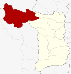
Amphoe Dan Chang
|
Dan Chang ด่านช้าง |
|
|---|---|
| Amphoe | |
 Amphoe location in Suphanburi Province |
|
| Coordinates: 14°50′30″N 99°41′50″E / 14.84167°N 99.69722°ECoordinates: 14°50′30″N 99°41′50″E / 14.84167°N 99.69722°E | |
| Country |
|
| Province | Suphanburi |
| Area | |
| • Total | 1,193.6 km2 (460.9 sq mi) |
| Population (2013) | |
| • Total | 67,011 |
| • Density | 54.0/km2 (140/sq mi) |
| Time zone | THA (UTC+7) |
| Postal code | 72180 |
| Geocode | 7203 |
Dan Chang (Thai: ด่านช้าง; IPA: [dàːn tɕʰáːŋ]) is the northwesternmost district (Amphoe) of Suphanburi Province, central Thailand.
Dan Chang was created as a minor district (King Amphoe) on August 30, 1974 by splitting off the three tambon Dan Chang, Ong Phra and Huai Khamin from Doem Bang Nang Buat district. The next year the subdistrict Nong Makha Mong was additionally transferred from Doem Bang Nang Buat to the minor district. The minor district was officially upgraded to a full district on July 13, 1981.
Lauda Air Flight 004 crashed in a site three nautical miles north of Phu Toei, Huai Khamin, Dan Chang in 1991.
Neighboring districts are (from the north clockwise) Ban Rai of Uthai Thani Province, Noen Kham of Chainat Province, Doem Bang Nang Buat and Nong Ya Sai of Suphanburi Province, and Lao Khwan, Nong Prue and Si Sawat of Kanchanaburi Province.
The Phu Toei National Park is located in Dan Chang district. The important water resource of Dan Chang is the Kra Siao river.
...
Wikipedia
