Ambrussum
| Ambrussum Oppidum, Pont Ambroix, Mutatio |
|
|---|---|

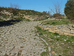
The paved road in the oppidum at the south gate leading from the Via Domitia, Ambrussum.
|
|
| Location | Ambrussum 34400 Villetelle |
| Coordinates | 43°43′N 4°09′E / 43.72°N 4.15°ECoordinates: 43°43′N 4°09′E / 43.72°N 4.15°E |
| Built | 4th century BC – 2nd century AD |
| Official name: Oppidum d'Ambrussum | |
| Type | Cultural Base Mérimée |
| Designated | 1974 |
| Reference no. | PA00103760 |
| Region | Europe and North America |
| Official name: Pont Ambroix | |
| Type | Cultural Base Mérimée |
| Designated | 1840 |
| Reference no. | PA00103057 |
|
|
|
Ambrussum is a Roman archaeological site in Villetelle, Hérault département, in southern France.
It is close to the modern town Lunel, between Nîmes and Montpellier. Ambrussum is notable for its museum, its staging post on the Via Domitia, its bridge Pont Ambroix over the Vidourle, painted by Gustave Courbet, and for its oppidum (fortified village). Its history of settlement spanned 400 years.
The whole site is still being excavated. A lower settlement prone to flooding was a staging post for travellers on the Via Domitia and provided stabling and accommodation and the full range of repair facilities that were needed by carts and the Imperial postal service. The higher settlement was based on a pre-Roman oppidum which was within a surrounding wall including 21 towers. The Romans re-modelled the oppidum, so there is evidence of a complete range of housing styles from the earliest one room dwellings to sophisticated courtyard houses on the second century AD.
The Roman road, the Via Domitia, ran at the foot of the settlement, leading from it is a paved road with visible with traces of Roman chariot tracks. The Roman bridge was used until the Middle Ages but fell into disrepair, and only one complete arch remains.
Ambrussum, or its alternative spelling of Ambrusium, is mentioned as a staging post (mutatio) on the Antonine Itinerary of AD 200, on pilgrims' guide on the route to the Holy Land of AD 333 and on the Peutinger map of 1520. All place it midway between Nimes (Nemausis) and Castelnau-le-Lez (Sextantio), that is 22 kilometres (14 mi) from each.
...
Wikipedia

