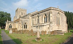
Ambrosden
| Ambrosden | |
|---|---|
 St Mary the Virgin parish church |
|
| Ambrosden shown within Oxfordshire | |
| Area | 7.26 km2 (2.80 sq mi) |
| Population | 2,248 (2011 Census) |
| • Density | 310/km2 (800/sq mi) |
| OS grid reference | SP5822 |
| Civil parish |
|
| District | |
| Shire county | |
| Region | |
| Country | England |
| Sovereign state | United Kingdom |
| Post town | Bicester |
| Postcode district | OX25 |
| Dialling code | 01869 |
| Police | Thames Valley |
| Fire | Oxfordshire |
| Ambulance | South Central |
| EU Parliament | South East England |
| UK Parliament | |
Ambrosden is a village and civil parish in Cherwell, Oxfordshire, England, 3 miles (5 km) southwest of Bicester to which it is linked by the A41 road, and 13 miles (21 km) from Oxford. The 2011 Census recorded the parish's population as 2,248. The parish is bounded by the River Ray to the south, its tributary the River Bure to the west, the outskirts of Bicester to the north and field boundaries to the east.
The village is 2 miles (3 km) east of Alchester Roman Town. Ambrosden has a Church of England parish church and a public house. Since the Second World War Ambrosden has housed British Army personnel stationed at St. George's Barracks, which is at Arncott about 1 1⁄2 miles (2.4 km) south of Ambrosden. The Ministry of Defence had many new houses built at Ambrosden in the early 1950s.
Ambrosden is about 3 miles (5 km) southwest of Bicester (the nearest railway station), connected by the A41 road. The site of Alchester Roman Town is about 2 miles (3 km) west of the village, and the village of Arncott is about 1 1⁄2 miles (2.4 km) to the south.
In 1932 Langford, Wretchwick, and Middle Wretchwick Farms, which were formerly part of the Bicester Market End township, were added to Ambrosden. The townships of Blackthorn and Arncott were part of Arncott but in the 20th century were detached to form separate parishes. The present Ambrosden parish is about 2 miles (3 km) wide both north–south and east–west.
...
Wikipedia

