Alvarães, Amazonas
| Alvarães | ||
|---|---|---|
| Municipality | ||
|
||
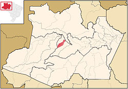
 Location of the municipality inside Amazonas |
||
| Location in Brazil | ||
| Coordinates: 3°13′15″S 64°48′15″W / 3.22083°S 64.80417°WCoordinates: 3°13′15″S 64°48′15″W / 3.22083°S 64.80417°W | ||
| Country |
|
|
| Region | North | |
| State |
|
|
| Government | ||
| • Mayor | Mário Tomás Litaiff (PMDB ) | |
| Area | ||
| • Total | 5,911.754 km2 (2,282.541 sq mi) | |
| Population (2015) | ||
| • Total | 15,546 | |
| • Density | 2.53/km2 (6.6/sq mi) | |
| Time zone | BRT (UTC−4) | |
| • Summer (DST) | DST no longer used (UTC−4) | |
| Climate | Af | |
Alvarães is a municipality located in the Brazilian state of Amazonas. Its population was 15,546 (2015) and its area is 5,912 km².
The municipality contains about 37% of the Tefé National Forest, created in 1989.
...
Wikipedia


