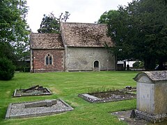
Alton, Wiltshire
| Alton Barnes | |
|---|---|
 St Mary the Virgin parish church, Alton Barnes |
|
| Alton Barnes shown within Wiltshire | |
| Population | 249 (in 2011) |
| OS grid reference | SU1062 |
| Civil parish |
|
| Unitary authority | |
| Ceremonial county | |
| Region | |
| Country | England |
| Sovereign state | United Kingdom |
| Post town | Marlborough |
| Postcode district | SN8 |
| Dialling code | 01672 |
| Police | Wiltshire |
| Fire | Dorset and Wiltshire |
| Ambulance | South Western |
| EU Parliament | South West England |
| UK Parliament | |
| Website | Alton Barnes, Alton Priors and Honeystreet |
Alton is a civil parish in Wiltshire, England. The parish includes the adjacent villages of Alton Barnes and Alton Priors, and the nearby hamlet of Honeystreet on the Kennet and Avon Canal. It lies in the Vale of Pewsey about 6 miles (10 km) east of Devizes.
The north of the parish is on the Marlborough Downs and includes part of Milk Hill, which is the highest point in Wiltshire at 295 metres (968 ft).
The area has prehistoric sites including the Knap Hill earthwork and Adam's Grave, a Neolithic long barrow. A hoard of Roman coins was discovered at Alton Barnes.
The boundaries of Alton Barnes parish were established in the early 10th century, and the ancient parish became a civil parish in 1866. Alton Priors was a chapelry of Overton parish, now West Overton, and became a separate civil parish in 1866. In 1934 the civil parishes of Alton Barnes and Alton Priors were abolished and merged to form the new civil parish of Alton.
In 1086 the Domesday Book records Edward of Salisbury as holder of the manor of Alton Barnes.
The Ridgeway, an ancient trackway, passes through Alton Barnes (although this section is not part of the Ridgeway National Trail, which begins further north). The Wansdyke, an early medieval earthwork, crosses the north of the parish on the Marlborough Downs.
...
Wikipedia

