Alterkülz
| Alterkülz | ||
|---|---|---|
|
||
| Coordinates: 50°01′56″N 7°27′57″E / 50.03222°N 7.46583°ECoordinates: 50°01′56″N 7°27′57″E / 50.03222°N 7.46583°E | ||
| Country | Germany | |
| State | Rhineland-Palatinate | |
| District | Rhein-Hunsrück-Kreis | |
| Municipal assoc. | Kastellaun | |
| Area | ||
| • Total | 7.58 km2 (2.93 sq mi) | |
| Elevation | 380 m (1,250 ft) | |
| Population (2015-12-31) | ||
| • Total | 433 | |
| • Density | 57/km2 (150/sq mi) | |
| Time zone | CET/CEST (UTC+1/+2) | |
| Postal codes | 56288 | |
| Dialling codes | 06762 | |
| Vehicle registration | SIM | |
| Website | www |
|
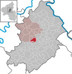
Alterkülz is an Ortsgemeinde – a municipality belonging to a Verbandsgemeinde, a kind of collective municipality – in the Rhein-Hunsrück-Kreis (district) in Rhineland-Palatinate, Germany. It is also a tourism community (Fremdenverkehrsgemeinde).
The municipality lies in the Külzbach valley, stretching strikingly along Landesstraße (State Road) 108, which is known locally as Hauptstraße (“Main Street”) where it actually passes through the village. Its length along this road has led to Alterkülz being called the “Longest Village in the Hunsrück”. Also belonging to the municipality is the outlying centre of Osterkülzmühle in the Osterkülz valley, southeast of the main centre.
Alterkülz’s neighbours, by compass direction, are as follows:
Alterkülz belonged until 1417 to the “Further” County of Sponheim, and locally to the Amt of Kastellaun. After this line of the Sponheims died out, the village went with Kastellaun to the “Hinder” part of the County.
Over the centuries, Alterkülz grew together from several villages: Unterdorf (“Lower Village”), Mitteldorf (“Middle Village”), Überbach and Wehr. As late as 1865, the now Ortsteil of Wehr was mentioned as a hamlet in its own right.
On the way out of the village to the south, near the Külzbach, the local river, are found remnants of a mediaeval iron smelter and what is left of the mine whence the ore came, the Grube Eid. Also found there is a slope on which once stood a Roman estate, a villa rustica.
...
Wikipedia


