Altares
| Altares | |||
| Civil parish (Freguesia) | |||
|
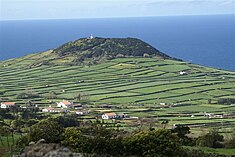
Pico Matias Simão an ancient volcanic spatter cone located near the coast of Altares
|
|||
|
|||
| Official name: Freguesia dos Altares | |||
| Name origin: Portuguese contraction of altos ares, meaning mountain breezes | |||
| Country | |||
|---|---|---|---|
| Autonomous Region | |||
| Island | Terceira | ||
| Municipality | Angra do Heroísmo | ||
| Rivers | Ribeira do Pamplona, Ribeira de Lapa, Ribeira da Luz, Ribeira de São Roque, Ribeira das Lajinhas, Ribeira dos Gatos | ||
| Center | Altares | ||
| - elevation | 132 m (433 ft) | ||
| - coordinates | 38°47′27″N 27°17′57″W / 38.79083°N 27.29917°WCoordinates: 38°47′27″N 27°17′57″W / 38.79083°N 27.29917°W | ||
| Highest point | Santa Bárbara | ||
| - elevation | 980 m (3,215 ft) | ||
| - coordinates | 38°44′29″N 27°18′52″W / 38.74139°N 27.31444°W | ||
| Lowest point | Sea Level | ||
| - location | Atlantic Ocean | ||
| Area | 28.22 km2 (11 sq mi) | ||
| - water | .01 km2 (0 sq mi) | ||
| - urban | .95 km2 (0 sq mi) | ||
| Population | 901 (2011) | ||
| Density | 32/km2 (83/sq mi) | ||
| Settlement | c. 1480 | ||
| LAU | Junta Freguesia | ||
| - location | Rua Patim | ||
| - coordinates | 38°47′29″N 27°17′55″W / 38.79139°N 27.29861°W | ||
| President Junta | Salvador da Rocha Lopes | ||
| President Assembleia | Hermínia da Conceição Pires Lopes Ferreira | ||
| Timezone | Azores (UTC-1) | ||
| - summer (DST) | Azores (UTC0) | ||
| Postal zone | 9700-306 | ||
| Area code & prefix | (+351) 295 9XX XXX | ||
| Demonym | Altarense | ||
| Patron saint | São Roque | ||
|
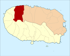
The civil parish (freguesia) within the municipality of Angra do Heroísmo (Azores), Portugal
|
|||
| Website: http://www.jfaltares.pt/ | |||
| Geographic detail from CAOP (2010) produced by Instituto Geográfico Português (IGP) | |||
Altares is a civil parish in the municipality of Angra do Heroísmo on the Portuguese island of Terceira in the archipelago of the Azores. The population in 2011 was 901, in an area of 28.22 km².
Situated on relatively flat land with fertile soils, although situated far from major population centres, the region was settled early, sometime before the year 1480. Owing to the severity of the coast, access to this region was obtained from the port of Biscoitos, some 6 kilometres (3.7 mi) east, and from the early settlement along the ravines of Quatro Ribeiras. The clearing and logging that proceeded along the territory, and from the agrarian structure and morphology of the land, settlement must have progressed from east to west, until the parish of Raminho (which was then known as Folhadais) was last to be settled.
Due the island's date of colonization and the progress of settlement along the north, the first occupation occurred around 1460, resulting in the foundation by the end of the 15th century. The fertility of the soils supported the establishment of agriculture and woad commerce (today remembered in the name of the Canada dos Engenhos) which helped establish the wealth of many of the Terceirense families. Referring to agriculture in Altares, Gaspar Frutuoso affirmed:
By the middle of the 15th century, the first important settlers arrived on the island, such as João Valadão, Gonçalo Álvares Pamplona (founder of Arrochela), Manuel Borges da Costa (descendent of João Borges "The Older", one of the first inhabitants on the island) and João Álvares Homem (relative of Álvaro Martins Homem), founder of the city of Angra. One of João Valadão daughters married Martim Simão (later identified with the toponymy of the parish, for example Pico de Matias Simão or Pico de Martim Simão).
It is unclear when the settlement was elevated to the status of parish, but it may have occurred before 1480, associated with a reference to a parish priest. The limits of the parish were relatively undefined, but included the northwest of the island, from Fajã (today an uninhabited site below Mata da Serreta and territory in the parish of Serreta) to the locality of Ponta Negra, including a part of Arrochela (today part of Biscoitos).
The centre of the parish, dominated by parochial church, was founded on the margins of the Ribeira de São Roque, in the immediate confluence of the Ribeira das Lajinhas, an area covered in vegetation and dominated by a large, evergreen bog. The settlement was supported by ravines and natural springs that ran from the mountainous Serra de Santa Bárbara, some 4 kilometres (2.5 mi) from the settlement.
...
Wikipedia


