Alta, Norway
|
Alta kommune Álttá gielda Alattion komuuni |
|||
|---|---|---|---|
| Municipality | |||

View of housing in Alta
|
|||
|
|||
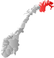
 Alta within Finnmark |
|||
| Coordinates: 69°58′36″N 23°17′45″E / 69.97667°N 23.29583°ECoordinates: 69°58′36″N 23°17′45″E / 69.97667°N 23.29583°E | |||
| Country | Norway | ||
| County | Finnmark | ||
| District | Vest-Finnmark | ||
| Administrative centre | Alta | ||
| Government | |||
| • Mayor (2015) | Monica Nielsen (Ap) | ||
| Area | |||
| • Total | 3,849.59 km2 (1,486.34 sq mi) | ||
| • Land | 3,653.36 km2 (1,410.57 sq mi) | ||
| • Water | 196.23 km2 (75.76 sq mi) | ||
| Area rank | 7 in Norway | ||
| Population (2015, Sept. 16th) | |||
| • Total | 20,000 ( |
||
| • Rank | 55 in Norway | ||
| • Density | 5.15/km2 (13.3/sq mi) | ||
| • Change (10 years) | 13.7 % | ||
| Demonym(s) | Altaværing | ||
| Time zone | CET (UTC+1) | ||
| • Summer (DST) | CEST (UTC+2) | ||
| ISO 3166 code | NO-2012 | ||
| Official language form | Bokmål | ||
| Website | www |
||
|
|
|||
Alta (![]() listen ; Northern Sami: Áltá;Kven: Alattio or Alta) is the most populated municipality in Finnmark county, Norway. The administrative centre of the municipality is the town of Alta. Some of the main villages in the municipality include Kåfjord, Komagfjord, Kvenvik, Langfjordbotn, Leirbotn, Rafsbotn, Talvik, and Tverrelvdalen.
listen ; Northern Sami: Áltá;Kven: Alattio or Alta) is the most populated municipality in Finnmark county, Norway. The administrative centre of the municipality is the town of Alta. Some of the main villages in the municipality include Kåfjord, Komagfjord, Kvenvik, Langfjordbotn, Leirbotn, Rafsbotn, Talvik, and Tverrelvdalen.
The municipality of Alten-Talvig was established on 1 January 1838 (see formannskapsdistrikt). On 1 January 1863, the municipality was divided into two: Talvik to the north (population: 1,938) and Alta to the south (population: 2,442). On 1 January 1964, the two municipalities were merged back together to form the new, larger municipality of Alta. Prior to the merger, Alta had 6,629 residents and Talvik had 3,266 residents. The borders have not changed since that time.
...
Wikipedia


